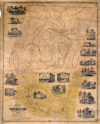
Map of the Town of Sharon, Litchfield Co. Conn.
SurveyorSurveyed by
Lawrence Fagan
American, born about 1825
DraftsmanDrawn by
Lawrence Fagan
American, born about 1825
DraftsmanVignettes drawn by
Edgar C. Beman
PrintmakerViews drawn on stone by
T. Watson
American, active 1853
PrintmakerLithographed by
Friend & Aub
American, founded 1852
PrinterPrinted by
Wagner & McGuigan
American, 1845 - 1859
PublisherPublished by
Richard Clark
American
Date1853
MediumLithography; black printer's ink and watercolor on wove paper mounted on fabric
DimensionsPrimary Dimensions (image height x width): 34 3/8 x 40 5/8in. (87.3 x 103.2cm)
Sheet (height x width): 37 x 43in. (94 x 109.2cm)
Sheet (height x width): 37 x 43in. (94 x 109.2cm)
ClassificationsGraphics
Credit LineConnecticut Museum of Culture and History collection
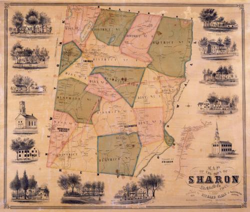
DescriptionMap of the town of Sharon, Connecticut, with Salisbury to the north, the Housatonic River and Cornwall to the east, Kent to the south, and New York State to the west. The town is divided into eleven districts. Three distinct villages are shown: Sharon, Hitchcock's Corner, and Ellsworth. Much of the terrain is hilly; elevation is conveyed by hachure marks. Roads and buildings are shown, with names of property owners. An inscription at the far right states "Housatonic R.R. 7 Miles from Sharon." A detailed map at lower right shows the village of Sharon with the names of property owners. Vignettes at left, right, and bottom include C. Sears' Harness and Trunk Manufactory, the Store and residence of S. J. Prindle, the Congregational Church in Sharon, the Congregational Church in Ellsworth, and the residences of R. S. Noyes, the Reverend G. L. Brownell, General Charles F. Sedgwick, the late John Cotton Smith, Ansel Sterling, Major David Gould, C. and R. B. Cole, Hiram Weed, and Samuel E. Everett.
Object number2012.312.289
MarkingsOn verso, upper left, on gummed label, typed in black ink, "MAPS / Case 4 / No. 1"On verso, upper right, on gummed label, typed in black ink, "MAPS / Case 4 / No. 1"InscribedOn recto, lower right, printed in black ink, "MAP / OF THE TOWN OF / SHARON / Litchfield Co. / CONN. / Drawn & Surveyed by L. FAGAN / Published by RICHARD CLARK 42 Moyamensing Road / PHILADELPHIA. / Map Lithd. by Friend & Aub Views by T. Watson Sketches by E. C. Beman Printed by Wagner & McGuigan / Scale, 3 Inches to 1 Mile / Entered according to act of Congress in the year 1853 by Richard Clark, in the Clerks office of the District court of the eastn. Dist. of Pa."
On verso, upper left, in pencil, "MAPS / Case 4 / No. 1"; in black ink, "TORRINGTON, CONN. ALFRED W. COOPER"
On verso, upper center, in pencil, "1359"
On verso, upper right, in pencil, "MAPS / Case 4 / No. 1"
On verso, lower right, in pencil, "2012.312.289"NotesCartographic Note: Three inches equal one mile
Collections
- Maps and Charts: Finding Your Place in Connecticut History
On View
Not on view