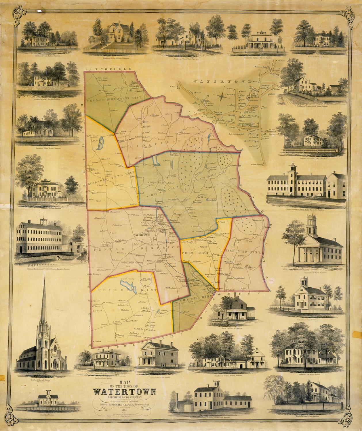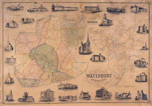
Map of the Town of Waterbury, New Haven County, Connecticut
SurveyorSurveyed by
H. Irvine
American
PrinterPrinted by
John F. Watson
American, active 1835 - 1861
PublisherPublished by
Richard Clark
American
Date1852
MediumLithography; black printer's ink and watercolor on wove paper mounted on fabric
DimensionsPrimary Dimensions (image height x width): 35 1/4 x 51in. (89.5 x 129.5cm)
Sheet (height x width): 39 5/8 x 53 1/4in. (100.6 x 135.3cm)
Sheet (height x width): 39 5/8 x 53 1/4in. (100.6 x 135.3cm)
ClassificationsGraphics
Credit LineMuseum purchase
DescriptionMap of the town of Waterbury, Connecticut, with Watertown, Plymouth, and Wolcott to the north and east; Naugatuck, Prospect, and Cheshire to the south; and Middlebury and Watertown to the west. The town is divided into ten districts, including the central borough. Inset maps show the villages of Waterbury and Waterville. Rivers, including the Naugatuck River and the Mad River, are shown, along with brooks and ponds. Elevation is indicated by hachure marks. Names of property owners and businesses are indicated. The Naugatuck Railroad parallels the Naugatuck River. Vignettes depict Abbott & Wardwell Manufacturing Company, Brown's Hotel, Warren & Newton Manufacturing Company, American Pin Company, the High School, Waterbury Knittinig Company, St. Paul's Chapel, Wm. R. Hitchcock & Co. Button Factory, Mattatuck Manufacturing Company, Brown & Elton Brass Rolling Mill, Waterbury Brass Company, Unionville Factory, Scovill Manufacturing Company, Scovill House, the Baptist Church, the Methodist Church, Waterbury Hook & Eye Company, Lane Manufacturing Company, Benedict & Burnham Manufacturing Company, the Roman Catholic Church, Hotchkiss & Merriman Manufacturing Company, the Congregational Church, the new Church of St. John's, Manhan Manufacturing Company, Waterville Manufacturing Company, and Brown Brothers Brass Rolling Mill.
Object number1956.95.5
MarkingsOn verso, upper left, on gummed label, typed in black ink, "Maps / Case 1 / No. 10"On verso, upperright, on gummed label, typed in black ink, "Maps / Case 1 / No. 10"InscribedOn recto, lower right, printed in black ink, "MAP / OF THE TOWN OF / WATERBURY / NEW HAVEN COUNTY / CONNECTICUT / FROM ACTUAL SURVEY BY / H. IRVINE / PUBLISHED BY / RICHARD CLARK / 384 SOUTH THIRD ST. / PHILADELPHIA / 1852"
On verso, upper left, in pencil, "MAPS / Case 1 / No. 10"
On verso, upper right, in pencil, "MAPS / Case 1 / No. 10"
On verso, lower right, in pencil, "1956.95.5"NotesCartographic Note: Four inches equals one mile
Collections
- Maps and Charts: Finding Your Place in Connecticut History
On View
Not on view