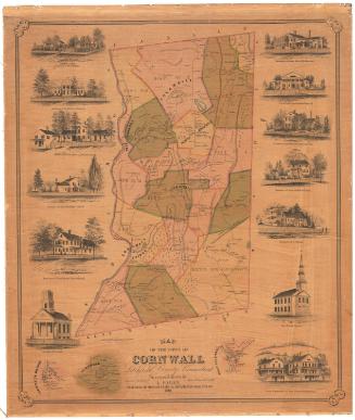
Map of the Town of Vernon, Tolland County, Conn.
SurveyorSurveyed by
E. M. Woodford
American, 1824 - 1862
PublisherPublished by
Richard Clark
American
PrinterLithographed by
Wagner & McGuigan
American, 1845 - 1859
Date1853
MediumLithography; black printer's ink and watercolor on paper
DimensionsPrimary Dimensions (image height x width): 33 1/4 x 40 5/8in. (84.5 x 103.2cm)
Sheet (height x width): 37 5/8 x 43in. (95.6 x 109.2cm)
Sheet (height x width): 37 5/8 x 43in. (95.6 x 109.2cm)
ClassificationsGraphics
Credit LineConnecticut Museum of Culture and History collection
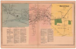
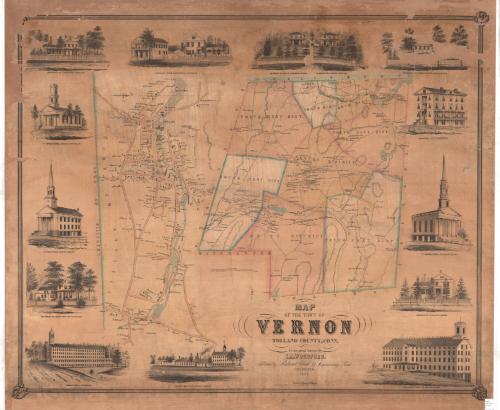
DescriptionPhysical and political map of Vernon, Connecticut, extending from Ellington to the north, Tolland to the east, Bolton to the south, and South Windsor to the west. Vernon is divided on the map into districts, all of which are labeled and outlined in a dotted line and pink or blue, except for the center district, which has no color. The Hartford, Providence and Fishkill Railroad runs through the town. Buildings and their owners are labeled, and elevation is denote with hachure marks. Bodies of water are blue.
To the left of the map of the town, there is a map of the village of Vernon, which extends from D. Hale's estate to the north, the Hockanum River to the east, S. Tracy's land to the south, and the border of the town of Ellington to the west. Roads, colored peach, are not labeled. Bodies of water appear in blue and are also unlabeled. Buildings are labeled with the names of their owners.
Around the map, clockwise from the top left, are thirteen vignettes: the residence of N. Kingsbury in Rockville; C. Hibbard's store and residence in Rockville; the residence of John W. Thayer in Rockville; the residence of A.C. Crosby in Rockville, the residence of Phineas Talcott, Esq., in Rockville; the Rockville Hotel; the 2nd Congregational Church in Rockville; the residence of N.O. Kellogg in Vernon; Rock Manufacturing Company's Mills in Rockville; N.O. Kellogg's woolen mill in Vernon; the American Mills in Rockville; the residence of George Kellogg in Rockville; the Congregational Church in Vernon; and the 1st Congregational Church in Rockville.
Object number2012.312.182
MarkingsRecto, bottom right corner, printed in black ink on sticker: "Maps / Oversize / Drawer / 3"InscribedRecto, center, printed in black ink: "SCALE OF RODS"Bottom center, printed in black ink: "MAP / OF THE TOWN OF / VERNON / TOLLAND COUNTY, CONN. / From actual Surveys by / E.M. WOODFORD. / Published by Richard Clark, 42 Moyamensing Road / PHILADELPHIA / 1853 / Printed by Wagner & McGuigan / Entered, according to act of congress in the year 1853 by Richard Clark in the Clerks office of the eastern District court of Pa"NotesCartographic Note: Scale: 1 inch equals 80 rods
Collections
- Maps and Charts: Finding Your Place in Connecticut History
On View
Not on view