"Proprietor's Map" of a portion of the town of Windsor, Connecticut lying east of the "Great River" and within the present bounds of Ellington, Connecticut as the land was originally laid out during the period 1728 - 1752
DraftsmanDrawn by
Alfred E. Schindler
American, born 1931
DraftsmanDrawn by
Mark O. Hoffman
American, born 1949
MakerBased on research by
Dorothy B. Cohen
American, 1917 - 2005
Date1985
MediumLithography; brown ink on wove paper
DimensionsPrimary Dimensions (image height x width): 35 3/8 x 63 5/8in. (89.9 x 161.6cm)
Sheet (height x width): 36 1/2 x 65in. (92.7 x 165.1cm)
Sheet (height x width): 36 1/2 x 65in. (92.7 x 165.1cm)
ClassificationsGraphics
Credit LineGift of Dorothy B. Cohen and Alfred E. Schindler
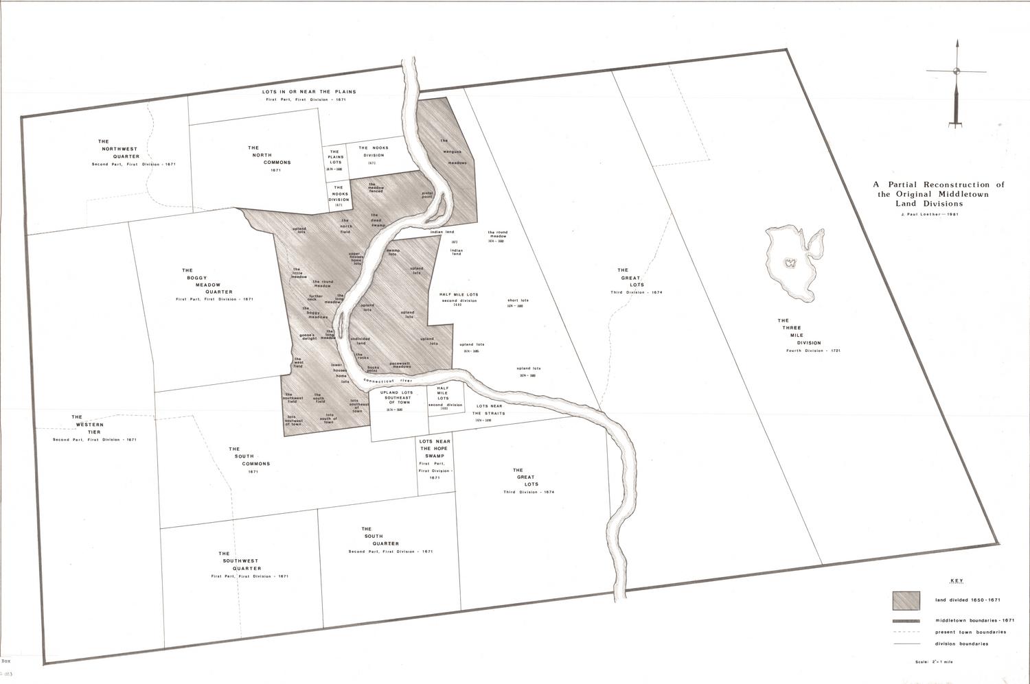
DescriptionLand ownership map of what was then part of Windsor, Connecticut, now known as Ellington, extending from the borders of Enfield, Somers and Stafford to the north, Willington to the east, South Windsor, Vernon and Tolland to the south, and East Windsor to the west. Plots of land are labeled with their number, their acreage and the owner's name. Divisions, called "Windsor Commons," "Mile-and-Half-Mile," "Sequestered Land" and "Equivolent," are labeled on the map, along with "tears," or divisions of 317 lots in one half-mile wide increments, separated by highway allowances. Roman numerals are used to identify the various land grantees.
Around the map, there are vignettes depicting animals, Native Americans, various dwellings, farming scenes, meetings and land surveying. A section located below the map, titled "General Notes, Background and Legend," provides information about Ellington's growth, the divisions of land, land grants, and the various grantees. The legend shows the lines that denote brooks, present highways, township lines, parish lines and fenced-in grant lands, as well as the symbols that represent parsonage sites, burial sites, saw-grist mills and schools. The cartouche shows three seals, those of Windsor, East Windsor and Ellington; two vignettes depicting discovery; a rifle; and a vignette showing men working to raise a house while Native Americans look on.
Around the map, there are vignettes depicting animals, Native Americans, various dwellings, farming scenes, meetings and land surveying. A section located below the map, titled "General Notes, Background and Legend," provides information about Ellington's growth, the divisions of land, land grants, and the various grantees. The legend shows the lines that denote brooks, present highways, township lines, parish lines and fenced-in grant lands, as well as the symbols that represent parsonage sites, burial sites, saw-grist mills and schools. The cartouche shows three seals, those of Windsor, East Windsor and Ellington; two vignettes depicting discovery; a rifle; and a vignette showing men working to raise a house while Native Americans look on.
Object number1985.238.0
InscribedRecto, bottom right, printed in black ink: ""Proprietor's Map" / of / a portion of the town of Windsor, Connecticut / lying east of the "Great River" / and within the present bounds of / Ellington, Connecticut / as the land was originally laid out during the period 1728 - 1752"Bottom right, printed in black ink: "MAP PREPARATION: COPYRIGHTED & PUBLISHED - 1985 / THIS MAP WAS PREPARED THROUGH THE JOINT EFFORTS AND / CONTRIBUTION OF THE FOLLOWING: / MAP RESEARCH & HISTORY : DOROTHY BLOCK COHEN, HISTORIAN / ELLINGTON, CONNECTICUT / MAPPING: ALFRED E. SCHINDLER, LAND SURVEYOR / ELLINGTON, CONNECTICUT / MARK O. HOFFMAN, ASSOCIATE / SCHINDLER SURVEYS / ELLINGTON, CONNECTICUT / ILLUSTRATION CREDITS [underlined]: / ACKNOWLEDGEMENT AND APPRECIATION IS EXTENDED TO THE FOLLOWING / ILLUSTRATION SOURCES: / The Story of America in Pictures, BY ALAN C. COLLINS, DOUBLEDAY & / COMPANY, INC., GARDEN CITY, N.J. / Surveying Our Public Lands, U.S. DEPARTMENT OF THE INTERIOR, BUREAU / OF LAND MANAGEMENT 1980 / The Growth of Industrial Art, BY BENJAMIN BUTTERWORTH, ALFRED A. / KNOPF, NEW YORK 1972 / The New England Indians, BY C. KEITH WILBUR, GLOBE PEQUOT PRESS, / CHESTER, CT 06412, WITH REPRINT PERMISSION GRANTED DEC. 31, 1984 / THE TOWNS OF Windsor, East Windsor AND Ellington, FOR THE USE OF / THEIR RESPECTIVE SEALS. / © COPYRIGHT 1984 ALFRED E. SCHINDLER / ELLINGTON. CONN. / Alfred E. Schindler [signature] / Dorothy B. Cohen [signature] / DOROTHY B. COHEN / ELLINGTON, CONN."NotesCartographic Note: Scale: 1 inch equals 3000 feet
Collections
- Maps and Charts: Finding Your Place in Connecticut History
On View
Not on view