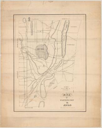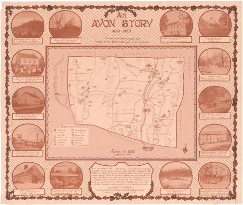
An Avon Story
DesignerDesigned by
Dorothy J. Anderson
American, 1921 - 1994
DesignerDesigned by
Gladys T. August
American, 1921 - 2013
DesignerDesigned by
Marian M. Hunter
American, 1917 - 1987
MakerResearched by
Dorothy J. Anderson
American, 1921 - 1994
MakerResearched by
Gladys T. August
American, 1921 - 2013
MakerResearched by
Marian M. Hunter
American, 1917 - 1987
Date1980
MediumLithography; brown printer's ink on wove paper
DimensionsPrimary Dimensions (image height x width): 22 1/8 x 26in. (56.2 x 66cm)
Sheet (height x width): 23 1/8 x 27 1/8in. (58.7 x 68.9cm)
Sheet (height x width): 23 1/8 x 27 1/8in. (58.7 x 68.9cm)
ClassificationsGraphics
Credit LineGift of the Avon Story Commission
DescriptionMap of the town of Avon in 1830, with Canton and Simsbury to the north, Windsor and Hartford to the east, Farmington to the south, and Burlington and the Farmington River to the west. Different areas of the town are labeled: "Whortleberry Hill," "Lovely Town," East Avon," "West Avon," "Old Farm," "Pine Woods," "Nod Division," "Nod Hill," and "Cider Brook." Drawings are used to show the locations of blacksmiths, grist and sawmills, taverns or inns, schoolhouses, cemeteries, churches, carding machines, turning mills, wagon shops, fulling mills, farming areas, distilleries, and canals and towpaths. Also depicted are the sites of historic events. Fourteen vignettes around the map show the West Avon Congregational Church; Nod School House; Avon Center; the former Holmes sawmill and gristmill; Canal Warehouse and Store; Avon Market; a team of horses and men harvesting ice; the Farmington River Wooden Bridge; the oldest house in Avon; Climax Fuse Company; Avon Creamery; Avon Heights; Wadsworth Tower; and the East Avon Congregational Church. Physical features include elevation, depicted with clusters of peaks, brooks, woods, and rivers.
Object number1980.101.0
MarkingsRecto, top and bottom left corners, printed in black ink on stickers: "MAPS / Drawer / 63"Verso, bottom left corner, stamped in blue ink: "THE CONNECTICUT / 81221 / HISTORICAL SOCIETY"InscribedRecto, top center, printed in brown ink: "An / AVON STORY / 1830-1980 / Scenes from Avon's past and / a map of the town in its year of incorporation"
Bottom center, printed in brown ink: "Avon was settled as the north parish in Farmington (Northington) in / the 1600's. Fertile land in the river valley attracted colonization. Early / settlers located near brooks and streams to be assured of a constant / water supply. These streams also supplied power for sawmills and / other industry. Centers of trade and social activity developed in / East Avon and Lovelytown. Roads were mere cartpaths carved / out by necessary travel. Most of Avon's 190 families were self- / sufficient, raising crops and animals for self preservation and barter. / Researched and designed by / Dorothy J. Anderson, Gladys T. August, Marian M. Hunter / Avon, Ct 1980"NotesCartographic Note: No scale
Collections
- Maps and Charts: Finding Your Place in Connecticut History
On View
Not on view