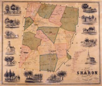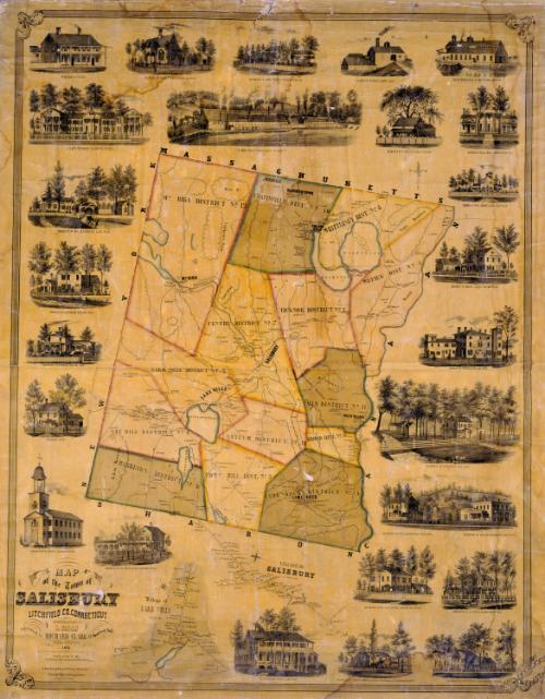
Map of the Town of Salisbury, Litchfield, Co., Connecticut
SurveyorSurveyed by
Lawrence Fagan
American, born about 1825
DraftsmanMap drawn by
Lawrence Fagan
American, born about 1825
DraftsmanSketches drawn by
Edgar C. Beman
PrintmakerLithographed by
Friend & Aub
American, founded 1852
PrinterPrinted by
Wagner & McGuigan
American, 1845 - 1859
PublisherPublished by
Richard Clark
American
Date1853
MediumLithography; black printer's ink and watercolor on wove paper mounted on fabric
DimensionsPrimary Dimensions (image height x width): 50 3/4 x 39 1/8in. (128.9 x 99.4cm)
Sheet (height x width): 53 x 42in. (134.6 x 106.7cm)
Sheet (height x width): 53 x 42in. (134.6 x 106.7cm)
ClassificationsGraphics
Credit LineConnecticut Museum of Culture and History collection
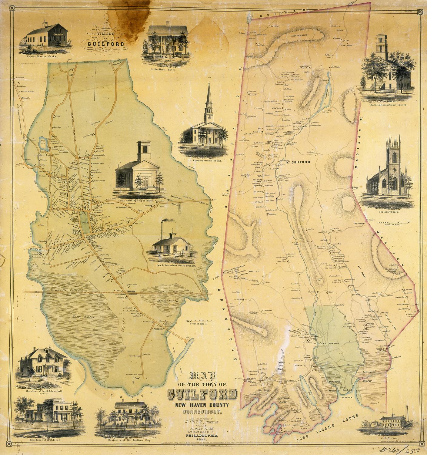
DescriptionMap of Salisbury, Connecticut with the state of Massachusetts to the north, the town of Canaan to the east, the town of Sharon to the south, and the state of New York to the west. The Housatonic River forms Salisbury's eastern boundary. The town is divided into thirteen districts. Roads, rivers, ponds, and mountains are indicated. Elevation is shown by hachure marks. Villages include Chapinville, Falls Village, LIme Rock, and Mount Riga. Separate inset maps at the bottom provide greater detail for the villages of Lakeville and Salisbury. All maps include the names of property owners and businesses. Vignettes surrounding the maps depict the Congregational Church and parsonage, William Bushnell's Hotel, A. J. Wardwell's Hotel, Ames Iron Works, the Landon Company Furnace, the Barnum Richardson and Company Iron Foundry, D. Clapp's Buildings, and the residences of H. Ames, R. Bostwick, Messrs. Read and Woodworth, Horace Landon, A. H. Holley, William H. Barnum, Leonard Richardson, M. B. Coffing, S. C. Scoville, Dea. Chittenden, J. H. Hubbard, Mrs. M. A. Holley, Walter F. Whittlesey, and John Adams.
Object number1952.102.0
MarkingsOn verso, upper left, on gummed label, typed in black ink, "MAPS / Case 3 / No. 7"; upper right, on gummed label, typed in black ink, "MAPS / Case 3 / No. 7"InscribedOn recto, lower left, printed in black ink, "MAP / of the Town of / SALISBURY / LITCHFIELD CO. CONNECTICUT / SURVEYED & DRAWN BY / L. FAGAN / Published by RICHARD CLARK 42 Moyamensing Road / PHILADELPHIA / 1853. / Entered according to act of Congress in the year 1853 by Richard Clark in the Clerks Office of the Eastern District court of Pa. / SCALE, 3 INCHES TO A MILE. / Lith. of Friend & Aub, 80 Walnut St. Philada. / Printed by Wagner & McGuigan, Phila. / Sketches by E.C. Benson"; upper left, in pencil, "59863"; lower right, in black crayon, "$55.00 / #551/"On verso, upper left, in pencil, "MAPS / Case 3 / No. 7"; upper right, in pencil, "MAPS / Case 3 / No. 7"; lower right, in pencil, "2012.312.284"NotesCartographic Note: Three inches equals one mile
Collections
- Maps and Charts: Finding Your Place in Connecticut History
On View
Not on view