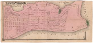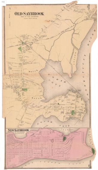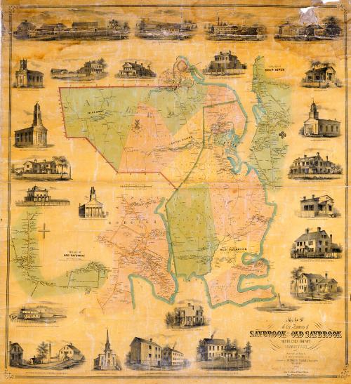
Map of the Towns of Saybrook and Old Saybrook, Middlesex County, Connecticut
SurveyorSurveyed by
E. M. Woodford
American, 1824 - 1862
PrintmakerLithographed by
Friend & Aub
American, founded 1852
DraftsmanDrawn by
E. M. Woodford
American, 1824 - 1862
PrinterPrinted by
Wagner & McGuigan
American, 1845 - 1859
PublisherPublished by
Richard Clark
American
Date1853
MediumLithography; black printer's ink and watercolor on wove paper mounted on fabric
DimensionsPrimary Dimensions (image height x width): 46 3/4 x 42 1/2in. (118.7 x 108cm)
Sheet (height x width): 48 3/4 x 45in. (123.8 x 114.3cm)
Sheet (height x width): 48 3/4 x 45in. (123.8 x 114.3cm)
ClassificationsGraphics
Credit LineConnecticut Museum of Culture and History collection
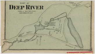
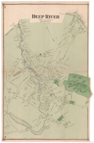
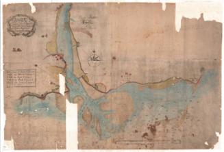
DescriptionMap of the towns of Saybrook and Old Saybrook, Connecticut, with Chester to the north, the Connecticut River to the east, Long Island Sound to the south, and Westbrook and Killingworth to the west. The locations of streams, forests, and marshes are indicated. Some roads are named and buildings are labelled with names of property owners. The New Haven and New London Railroad and the railroad ferry and a steam ferry across the Connecticut River are shown. Separate detailed map show the villages of Old Saybrook and Deep River and the borough of Essex. Saybrook Fort appears on both the main map and the detailed map of Old Saybrook. Vignettes surrounding the maps depict Saybrook Point Lighthouse, Saybrook Bank in Essex, Grace Church in Old Saybrook, College Place at Saybrook Point, Deep River Bank, the Baptist Church in Essex, Union House in Essex (a hotel with a tavern sign), the Methodist Episcopal Church in Essex, the First Congregational Church in Old Saybrook, Pratt Brothers Ivory Works, S. M. Comstock and Company's Comb Manufactory, Jennings and Company's Manufactory of Augurs, Gimblets, etc., N. B. Pratt's Factory, R. S. Williams's Pump Machinery, George Read and Company's Ivory Comb Manufactory, and the residences of Ulysses Pratt, E. S. Williams, Rev. H. Wooster, O. Cobb, W. P. Vinal, R. E. Pratt, A. Sheffield, and Captain E. E. Morgan.
Object number2012.312.294
MarkingsOn verso, upper left, on gummed label, typed in black ink, "MAPS / Case 4 / No. 15"On verso, upper right, on gummed label, typed in black ink, "MAPS / Case 4 / No. 15"InscribedOn recto, lower right, printed in black ink, "MAP / of the Towns of / SAYBROOK AND OLD SAYBROOK / MIDDLESEX COUNTY / CONNECTICUT / Surveyed and drawn by / E.M. WOODFORD, C.E. / Published by RICHARD CLARK 42 Moyamensing Road, / PHILADELPHIA / 1853 / Entered according to act of Congress in the year 1853 by Richard Clark in the Clerks office of the District court for the eastern District of Pa. / Lith. of Friend & Aub, 80 Walnut St. Phila. / Wagner & McGuigan's Steam Lith Press"
On verso, upper left, in pencil, "MAPS / Case 4 / No. 15"
On verso, upper center, in pencil, "1358a"
On verso, upper right, in pencil, "MAPS / Case 4 / No. 15"
On verso, lower right, in pencil, "2012.312.294"NotesCartographic Note: One inch equals 100 rods (main map); one inch equals 20 rods (village maps)
Collections
- Maps and Charts: Finding Your Place in Connecticut History
On View
Not on view