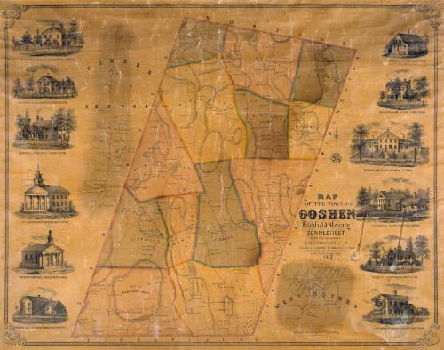
Map of the Town of Goshen, Litchfield County, Connecticut
SurveyorSurveyed by
E. M. Woodford
American, 1824 - 1862
DraftsmanDrawn by
E. M. Woodford
American, 1824 - 1862
PrintmakerLithographed by
Friend & Aub
American, founded 1852
PrinterPrinted by
Wagner & McGuigan
American, 1845 - 1859
MakerMade by
Richard Clark
American
Date1852
MediumLithography; black printer's ink and watercolor on wove paper mounted on fabric
DimensionsPrimary Dimensions (image height x width): 30 1/2 x 38 3/4in. (77.5 x 98.4cm)
Sheet (height x width): 33 x 40 3/4in. (83.8 x 103.5cm)
Sheet (height x width): 33 x 40 3/4in. (83.8 x 103.5cm)
ClassificationsGraphics
Credit LineConnecticut Museum of Culture and History collection
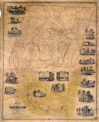
DescriptionMap of the town of Goshen, Connecticut, with Norfolk to the north, Torrington and Winchester to the east, Litchfield to the south, and Cornwall to the west. The town is divided into twelve school districts but only ten districts are numbered. Roads, including the Sharon Turnpike and turnpike gate, streams,ponds, and hills are shown. Elevation is indicated by hachure marks. Names of property owners are indicated. Separate inset maps provide additional detail for Goshen Centre and West Goshen. Vignettes at left and right depict the first Congregational Church, the Methodist Episcopal Church, A. Miles and Son's Store, and the residences of the Reverend Lavalette Perrin, Moses Lyman, Giles Griswold, Erastus Lyman, General M. Cook, Milo Bartholomew, Cephus Ives, Cicero Collins, and Frederick Lyman.
Object number2012.312.288
MarkingsOn verso, upper left, on gummed label, typed in black ink, "MAPS / Case 3 / No. 16"On verso, upper right, on gummed label, typed in black ink, "MAPS / Case 3 / No. 16"InscribedOn recto, lower right, printed in black ink, "MAP / OF THE TOWN OF / GOSHEN / Litchfield County / CONNECTICUT / SURVEYED AND DRAWN BY / E. M. WOODFORD, C.E. / Published by RICHARD CLARK, 384, Sth 3rd St. Philada. / LITH BY FRIEND & AUB, 80 WALNUT ST. PHILADA. / Printed by Wagner & McGuigan, Philada. / 1852 / Entered according to act of Congress in the year 1852 by Richard Clark in the Clerk's Office of the District Court of the Eastern Dist. of Pennsa."
On verso, upper left, in pencil, "MAPS / Case 3 / No. 16"; upper right, in pencil, "MAPS / Case 3 / No. 16"; lower right, in pencil, "2012.312.288"NotesCartographic Note: One inch equals 100 rods
Collections
- Maps and Charts: Finding Your Place in Connecticut History
On View
Not on view