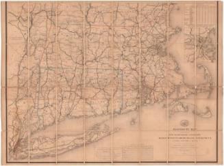
Smith's Railroad, Steamboat & Stage Route Map of New England, New-York and Canada
PublisherPublished by
John Calvin Smith
American, 1810 - 1890
Date1858
MediumEngraving; black printer's ink and watercolor on wove paper, in cardboard covers
DimensionsPrimary Dimensions (image height x width): 21 1/4 x 26 7/8in. (54 x 68.3cm)
Sheet (height x width): 21 7/8 x 27 3/8in. (55.6 x 69.5cm)
Sheet (height x width): 21 7/8 x 27 3/8in. (55.6 x 69.5cm)
ClassificationsGraphics
Credit LineConnecticut Museum of Culture and History collection
DescriptionPocket map of the New England states, New York, and Upper and Lower Canada (present-day Ontario and Quebec), depicting the transportation options of the area. None of the routes shown are named. Physical features depicted include elevation, conveyed with hachure marks; rivers; and lakes. On the right side are inset maps of the greater Boston and New York City areas. Around the map are vignettes showing Niagara Falls, Notch White Mountains, Mont Morenci Falls, ships at sea, and the view from Mount Holyoke.
Object number1988.231.0
MarkingsInside cover, center, stamped in blue ink: "CtHi"InscribedFront cover, gold tooled: "SMITH'S / NEW GUIDE / AND / RAILROAD MAP / OF / NEW ENGLAND, / NEW YORK / AND / CANADA"Inside cover, center, handwritten in pencil: "88684"
Recto, top left, printed in black ink: "Published by / J. CALVIN SMITH / 71 Nassau St. N.Y. / MDCCCLVIII"
Top center, printed in black ink: "SMITH'S / RAILROAD, STEAM BOAT & STAGE ROUTE MAP / OF / NEW ENGLAND, / NEW-YORK / AND / CANADA / BY / J. CALVIN SMITH"
Bottom, printed in black ink: "Entered according to act of Congress in the Year 1855 by J. Calvin Smith in the Clerks Office of the District Court for the Southern District of New York"NotesCartographic Note: Scale: 1 inch equals about 25 miles
Collections
- Maps and Charts: Finding Your Place in Connecticut History
On View
Not on view