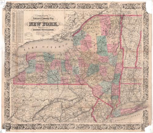
Colton's Railroad and Township Map of the State of New York
DraftsmanDrawn by
George W. Colton
American, 1827 - 1901
PrintmakerEngraved by
J. M. Atwood
American, active about 1840 - 1875
PublisherPublished by
J. H. Colton & Co.
American, founded 1831
Date1856
MediumEngraving; black printer's ink and watercolor on wove paper
DimensionsPrimary Dimensions (image height x width): 25 x 28 1/4in. (63.5 x 71.8cm)
Sheet (height x width): 25 1/4 x 28 3/4in. (64.1 x 73cm)
Sheet (height x width): 25 1/4 x 28 3/4in. (64.1 x 73cm)
ClassificationsGraphics
Credit LineConnecticut Museum of Culture and History collection
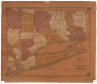
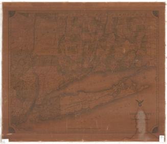
DescriptionMap of the state of New York, from part of Ontario, Canada, to the north; Vermont and parts of Massachusetts and Connecticut to the east; parts of Pennsylvania and New Jersey to the south; and Lake Erie to the west. New York is divided into counties, colored pink, blue or yellow and separated by broken solid lines; and towns, separated by thin solid lines. The counties and towns of the adjoining states are similarly depicted, without color. Railroad lines shown include the New York and Erie; Buffalo and New York City; Buffalo, Corning and New York; Niagara Falls; Rochester and Syracuse Direct; Williamsport and Elmira; Syracuse and Binghamton; Watertown and Rome; Central; New York and Harlem; and the Hudson River Railroads. Also shown are canals. Physical features depicted include elevation, conveyed through hachure marks, rivers, lakes and islands. In the top left corner is a list of New York counties, their populations in 1840 and 1850, the number of farms and "productive establishments."
Object number2012.312.100
MarkingsRecto, top and bottom left corners, printed in black ink on sticker: "MAPS / Drawer / 41"InscribedRecto, top left, printed in black ink: "COLTON'S / Railroad & Township Map / OF THE STATE OF / NEW YORK, / With Parts of the / ADJOINING STATES & CANADA. / Published by J.H. Colton & Co. / No. 172 William St. New York / 1856."Bottom left, printed in black ink: "Drawn by Geo. W. Colton"
Bottom right, printed in black ink: "J.M. Atwood Sculp."
Bottom right, printed in black ink: "Entered according to Act of Congress in the Year 1852 by J.H. Colton, in the Clerk's Office of the Dist. Court for the Southern Dist. of N. York"
Verso, center, handwritten in red ink: "40.841"NotesDate Note: Map is apparently a re-issue of a map originally published in 1852.
Cartographic Note: 1/2 inch equals about 8 miles
Collections
- Maps and Charts: Finding Your Place in Connecticut History
On View
Not on view

Lucius Stebbins & Co.
1859