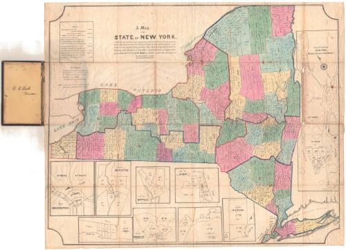
A Map of the State of New York
PrinterLithographed by
E.B. & E.C. Kellogg
American, 1840 - 1867
Dateprobably between 1840 and1847
MediumLithography; printer's ink and watercolor on wove paper, folded, in cardboard covers
DimensionsPrimary Dimensions (image height x width): 26 3/4 x 32in. (67.9 x 81.3cm)
Sheet (height x width): 27 1/4 x 33in. (69.2 x 83.8cm)
Folder (height x width): 7 1/4 x 4 1/2in. (18.4 x 11.4cm)
Sheet (height x width): 27 1/4 x 33in. (69.2 x 83.8cm)
Folder (height x width): 7 1/4 x 4 1/2in. (18.4 x 11.4cm)
ClassificationsGraphics
Credit LineThe Newman S. Hungerford Museum Fund
DescriptionPolitical map of the state of New York, with Lake Erie and Lake Ontario on the north and west and Long Island to the south. Counties and towns are shown on the main large map. Small inset maps show the cities of Schenectady, Rochester, Troy, Buffalo, Albany, Brooklyn, Utica, Hudson, New York City and Williamsburgh, divided into wards. The population of each ward, town, and county is indicated. Some of the individual inset maps have arrows indicating the direction of north. The orientation of these inset maps varies.
Object number2010.291.0
InscribedOn recto, upper center, printed in black ink, "A Map / of the / STATE OF NEW YORK / exhibiting the situation and boundaries of the several Towns, Wards, and Coun-/ties and specifying in each Town, Ward, and County, the whole population thereof, and / in the several counties, the population upon which the apportionment of / Senators and Members of Assembly is based, with tables of apportion/ment. Prepared for the NEW-YORK Legislature under the direction of / the Secretary of State."On verso, lower right, in pencil, accession number
On inside front cover of folder, in pencil, "(HH20) / #6393 / 1500 / 32763 / 6393"; in black ink, "C. C. Cook. / Clinton."; lower left, in pencil, accession numberNotesCartographic Note: No scale
Date Note: The Kellogg firm was known as E. B. & E.C. Kellogg between 1840 and 1847 and between 1855 and 1867. This map probably dates from the earlier period.
Collections
- Maps and Charts: Finding Your Place in Connecticut History
On View
Not on view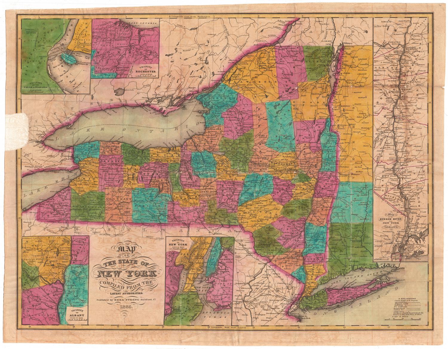


Kellogg & Bulkeley
1910-1915
Kellogg & Bulkeley
1915-1920