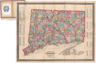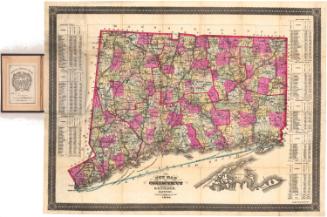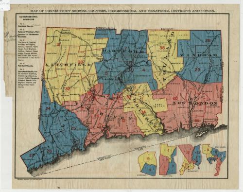
Map of Connecticut showing counties, congressional and senatorial districts and towns.
PrinterPrinted by
Kellogg & Bulkeley
American, 1867 - 1990
Date1910-1915
MediumLithography; black and colored printer's inks on wove paper
DimensionsPrimary Dimensions (image height x width): 10 7/16 x 13 1/2in. (26.5 x 34.3cm)
Sheet (height x width): 11 5/8 x 14 7/8in. (29.5 x 37.8cm)
Sheet (height x width): 11 5/8 x 14 7/8in. (29.5 x 37.8cm)
ClassificationsGraphics
Credit LineConnecticut Museum of Culture and History collection
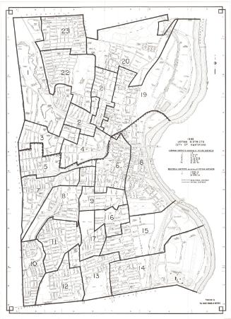
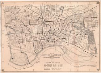
DescriptionMap of the state of Connecticut, with Massachusetts to the north, Rhode Island to the east, the Long Island Sound and the boundary line between Connecticut and New York to the south, and New York to the west. The state is divided into towns, counties and senatorial districts, with towns doubling as congressional districts and denoted with solid lines, while county divisions are represented by the use of pink, yellow or blue color. The 35 state senatorial districts are outlined in red and are numbered. To the left of the map is a list of the five (federal) congressional districts, with the county and, in some cases, the towns that make up the district. Below the main map are four inset maps of Waterbury, Hartford, Bridgeport and New Haven, divided into wards and state senatorial districts. The following railroad lines are delineated on the map: New York, New Haven and Hartford; Ridgefield; Shepaug, Central New England; Western; Philadelphia Reading; New London Northern; Northern; and Boston and Hartford Air Line Railroads.
Object number2012.312.60
MarkingsRecto, top left, printed in black ink on sticker: "MAPS / Box / 191"InscribedRecto, top, printed in black ink: "MAP OF CONNECTICUT SHOWING COUNTIES, CONGRESSIONAL AND SENATORIAL DISTRICTS AND TOWNS."Bottom left corner, printed in black ink: "KELLOGG & BULKELEY CO., HARTFORD, CONN."
Top left, handwritten in pencil next to "Hartford County" under "Congressional Districts": "Columbia [?]"
Top left, handwritten in pencil: Three illegible names
In pencil within most of the town boundaries, someone has inscribed the town's date of incorporation
Verso, top left corner, handwritten in pencil: "Maps / Flat / 85"NotesCartographic Note: No scale
Date Note: While the exact date of this map is unknown, the presence of the town of Chatham indicates that it was made sometime before 1915, as in that year Chatham became East Hampton.
Collections
- Maps and Charts: Finding Your Place in Connecticut History
On View
Not on view
Kellogg & Bulkeley
1915-1920