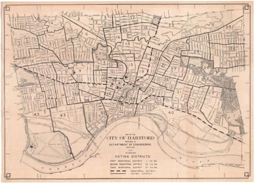
Map of the City of Hartford
MakerPrepared by
Engineering Department (Hartford, Conn.)
American, founded 1907
Date1957
MediumLithography; black printer's ink on wove paper
DimensionsPrimary Dimensions (image height x width): 21 3/4 x 30 1/4in. (55.2 x 76.8cm)
Sheet (height x width): 22 1/2 x 31 1/8in. (57.2 x 79.1cm)
Sheet (height x width): 22 1/2 x 31 1/8in. (57.2 x 79.1cm)
ClassificationsGraphics
Credit LineConnecticut Museum of Culture and History collection
DescriptionMap of the city of Hartford with West Hartford to the west, Bloomfield and Windsor to the north, the Connecticut River to the east, and Wethersfield to the south. Streets, highways, rivers, ponds, and parks are shown. Small circles indicate trees. Brainard Field and the Metropolitan Distict Sewage Treatment Plant are at lower left. Solid black lines divide the city into forty-five numbered voting districts. Heavy broken lines indicate the three senatorial districts. The map is oriented with north to the right.
Object number2012.312.266
InscribedOn recto, lower center, printed in black ink, "MAP OF THE / CITY OF HARTFORD / PREPARED BY / DEPARTMENT OF ENGINEERING / HARTFORD / 1957 / SHOWING / VOTING DISTRICTS / FIRST SENATORIAL DISTRICT 1-19 INC. / SECOND SENATORIAL DISTRICT 20-36 INC. / THIRD SENATORIAL DISTRICT 37-45 INC. / [heavy broken line] SENATORIAL DISTRICT / [solid black line] VOTING DISTRICT"On verso, lower right, in pencil, "2012.312.266"NotesCartographic Note: No scale
Collections
- Maps and Charts: Finding Your Place in Connecticut History
On View
Not on view

Kellogg & Bulkeley
1910-1915
Kellogg & Bulkeley
1915-1920


