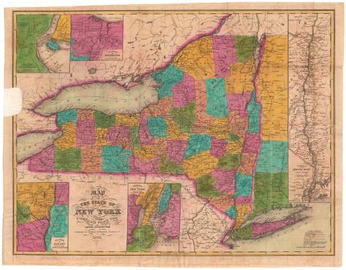
Map of the State of New York
PublisherPublished by
Ezra Strong
American, 1805 - 1846
Date1835
MediumEngraving; black printer's ink and watercolor on wove paper, lined with paper
DimensionsPrimary Dimensions (image height x width): 16 1/2 x 21 5/8in. (41.9 x 54.9cm)
Sheet (height x width): 17 7/8 x 22 3/4in. (45.4 x 57.8cm)
Mount (height x width): 17 7/8 x 22 3/4in. (45.4 x 57.8cm)
Sheet (height x width): 17 7/8 x 22 3/4in. (45.4 x 57.8cm)
Mount (height x width): 17 7/8 x 22 3/4in. (45.4 x 57.8cm)
ClassificationsGraphics
Credit LineConnecticut Museum of Culture and History collection
DescriptionMap of New York, extending from the Canadian border to the north; Vermont, Massachusetts and Connecticut to the east; Pennsylvania and New Jersey to the south; and Lake Erie to the west. Five inset maps, Niagara Falls, Rochester, Hudson River Valley, New York City, and Albany, surround the main map. New York's counties are outlined in dotted lines, labeled, and colored pink, orange, yellow, green or blue. State boundaries and the border with Canada are marked in broken solid and dotted lines. Bodies of water are marked on all of the maps, while swamps are only present on the insets. Other features include finished and proposed canals, railroads and proposed railroads, turnpike roads and common roads.
Object number2012.312.80
MarkingsRecto, top left, printed in black ink on sticker: "MAPS / Box / 175"InscribedRecto, bottom left, printed in black ink: "MAP / OF / THE STATE OF / NEW YORK / COMPILED FROM THE / LATEST AUTHORITIES / Published by EZRA STRONG Hartford, Ct. / 1835."Bottom right, printed in black ink: "EXPLANATION / Canals finished or in Progress / represented thus [solid line] / Proposed Canals [double broken solid line] / Rail Roads [line of diamonds] / Pro. Rail Roads [broken line] / Turnpike Roads [triple solid line] / Common Do. [narrow double solid line] / County Towns [circle with dot in center ] The figures along the Roads indicate the / distances in Miles from Place to Place. / Scale of Miles"
Top left, printed in black ink: "VICINITY / OF THE / FALLS OF NIAGARA / SCALE OF MILES"
Top left, printed in black ink: "VICINITY / OF ROCHESTER / SCALE OF MILES"
Right side, printed in black ink: "Map / of the / HUDSON RIVER / from / NEW YORK / to / ALBANY / SCALE"
Bottom center, printed in black ink: "VICINITY / OF / NEW YORK / SCALE OF MILES"
Bottom left, printed in black ink: "VICINITY / OF / ALBANY / SCALE OF MILES"
Verso, top left, handwritten in pencil: "Maps / Flat / 32"NotesCartographic Note: Scale [main map]: 1 inch equals approximately 22 miles
Scale, inset map of Niagara Falls: 3/4 of an inch equals approximately 1/2 mile
Scale, inset map of Rochester: 1 inch equals 8 miles
Scale, inset map of the Hudson River: 3/4 of an inch equals 10 miles
Scale, inset map of New York: 7/8 of an inch equals 4 miles
Scale, inset map of Albany: 1 inch equals 8 miles
Collections
- Maps and Charts: Finding Your Place in Connecticut History
On View
Not on view