Santiago de Cube
DraftsmanDrawn by
Charles H. Ourand
American, 1857 - after 1920
PrintmakerLithographed by
Julius Bien
1826 - 1909
Original OwnerOriginally owned by
Brigadier General George Malpas Cole
American, 1853 - 1933
Date1898
MediumLithography; black and red printer's ink on cotton
DimensionsPrimary Dimensions (image height x width): 38 5/8 x 23 3/4in. (98.1 x 60.3cm)
Sheet (height x width): 41 5/8 x 26 7/8in. (105.7 x 68.3cm)
Sheet (height x width): 41 5/8 x 26 7/8in. (105.7 x 68.3cm)
ClassificationsGraphics
Credit LineGift of Miss Clara B. M. Cole
DescriptionMap of part of the province of Santiago de Cuba. Places are marked with their name and a circular symbol. Roads and what appear to be railroads are shown. Physical features include islands and rivers. Water depth is measured in fathoms; height is measured in feet. Other numbers are shown around on the map, in the areas representing water. Some of the numbers have letters representing some kind of units of measurement, although what they are is unclear. Below the title is list of the symbols denoting capitals, district seats, boundary lines, railroads, and roads. The abbreviations listed below signify physical features such as rivers, swamps, and hills; farms; sugarmills; harbors; shops and more. In the bottom is an inset index map showing all of the maps in the series.
Object number1953.56.25
InscribedRecto, top left, printed in black ink: "ADJUTANT GENERAL'S OFFICE, M.I.D."Top right, printed in black ink: "CUBA - SHEET No. 8"
Top, printed in black ink: "MILITARY MAP / OF THE / ISLAND OF CUBA / Prepared in the / WAR DEPARTMENT, ADJUTANT GENERAL'S OFFICE / MILITARY INFORMATION DIVISION / From the Latest Official Sources / 1898"
Bottom left, printed in black ink :"JULIUS BIEN & CO PHOTO. LITH."
Bottom right, printed in black ink: "Drawn by C.H. Ourand"
Bottom right, handwritten in black ink: "2082"
NotesCartographic Note: Scale: 1:250,000
Medium Note: Most sources state that cloth maps were first used by the American military in World War II, but this map is part of a series of cloth maps of Cuba produced by the Adjutant General's Office for use during the Spanish American War.
Collections
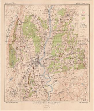
- Maps and Charts: Finding Your Place in Connecticut History
On View
Not on view