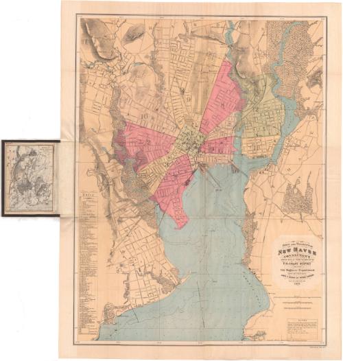
City and Vicinity of New Haven, Connecticut, Derived Wholly from the maps of the U.S. Coast Survey and of the City Engineer Department
After a work byAfter a work by
United States Coast Survey
American, founded 1807
DraftsmanDrawn by
James P. Bogart
1852 - 1903
DraftsmanDrawn by
Horace Andrews
American, 1852 - 1945
PrintmakerLithographed by
Julius Bien
1826 - 1909
Date1877
MediumLithography; black and colored printer's inks on wove paper, in cardboard covers
DimensionsPrimary Dimensions (image height x width): 27 7/8 x 21 1/2in. (70.8 x 54.6cm)
Sheet (height x width): 30 1/8 x 23 7/8in. (76.5 x 60.6cm)
Sheet (height x width): 30 1/8 x 23 7/8in. (76.5 x 60.6cm)
ClassificationsGraphics
Credit LineConnecticut Museum of Culture and History collection
DescriptionPocket map of New Haven, Connecticut, and the surrounding area. The City is divided into 12 wards, colored pink, green, yellow or beige. Streets are labeled and 128 churches, hotels and public halls, educational institutions, banks and miscellaneous buildings are numbered and listed in an index on the left side. The New Haven and Northampton; New Haven and Derby; Boston and New York Air Line; and New York, New Haven and Hartford Railroads run through the city. Physical land features include elevation, conveyed through hachure marks, and swamps. In the harbor, water depth is measured in feet, and contour lines show where the depth is below 3, 6, 12 and 18 feet. The West, Mill and Quinnipiac Rivers are also shown. On the inside cover is a map of the region of New Haven, which shows more of the surrounding terrain to the town line of Cheshire to the north. There are letters on this map that correspond to an index on the inside back cover.
Object number1936.34.0
InscribedFront cover, gold tooled: "MAP / OF / NEW HAVEN / AND / VICINITY"Inside cover, top left, handwritten in red ink: "46667"
Top right, printed in black ink: "REGION OF / NEW HAVEN / CONNECTICUT / 1877"
Bottom left, printed in black ink: "Compiled chiefly from U.S. Coast Survey data"
Bottom right, printed in black ink: "James P. Bogart del."
Recto, lower right, printed in black ink: "CITY AND VICINITY OF / NEW HAVEN / CONNECTICUT / DERIVED WHOLLY FROM THE MAPS OF THE / U.S. COAST SURVEY / AND OF THE / City Engineer Department / DRAWN AND PUBLISHED BY / JAMES P. BOGART AND HORACE ANDREWS / 1877."
Bottom right, printed in black ink: "Copyright, 1877, by James P. Bogart and Horace Andrews."
Bottom right, printed in black ink: "Photo Lith by J. Bien. N.Y."
Verso, left side, handwritten in pencil: "Maps / 46667"NotesCartographic Note: Scale, Region of New Haven: 1 inch equals 3 miles; City and Vicinity of New Haven: 4 inches equals 1 mile
Collections
- Maps and Charts: Finding Your Place in Connecticut History
On View
Not on view

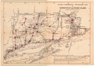
Blum's Commercial Map Publishing Company
1927-1928