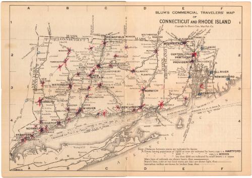
Blum's Commerical Travelers' Map of Connecticut and Rhode Island
PublisherPublished by
Blum's Commercial Map Publishing Company
American, founded 1910
Date1927-1928
MediumLithography; black printer's ink on wove paper, in paper covers
DimensionsPrimary Dimensions (image height x width): 9 x 12 5/8in. (22.9 x 32.1cm)
Sheet (height x width): 9 1/2 x 13 5/8in. (24.1 x 34.6cm)
Sheet (height x width): 9 1/2 x 13 5/8in. (24.1 x 34.6cm)
ClassificationsGraphics
Credit LineMuseum purchase
DescriptionPocket map of Connecticut and Rhode Island, with the borders of Massachusetts to the north and east, Long Island and the Long Island Sound to the south, and the border of New York to the west. Main and branch railroad lines, predominantly of the New York, New Haven and Hartford Railroad (marked N.H.), are prominently depicted on the map, with stations marked in circles and figures that are probably distances between stations shown. The other railroad line shown is the Central New England. Interurban trolley routes and steam boat routes in the Long Island Sound and Narragansett Bay are also shown. On the inside covers and back of the map are hotel directories by town for Connecticut and Rhode Island that contain information about hotels' rates, the town's population, the hotels' locations, and the local industry. Following the directories are lists of cities in each state having populations of less than 5,000, and lists of the legal holidays. On the back of the cover is a guide for how to use the map.
Object number1993.174.1
MarkingsFront cover, bottom, printed in black ink on label: "Supplied by / C.S. HAMMOND & COMPANY / MAP SPECIALISTS / NEW YORK AND BOSTON"InscribedFront cover, printed in black ink: "CONNECTICUT AND RHODE ISLAND / Price 25 Cents / 1927-1928 Edition / BLUM'S / Commercial Travelers' / Map / of CONNECTICUT and / RHODE ISLAND / SHOWING / RAILWAY SYSTEMS / RAILWAY DISTANCES / INTERURBAN TROLLEYS / LEADING INDUSTRIES and / Indexed Locations of all towns / having a population of 1000 or more. / Location of all Junction Points. / Population as per Census of 1920. / Directory of Comercial Hotels, / Hotel Rates, etc."Back cover, top right, handwritten in pencil: "Maps / 91624"
Bottom, printed in black ink: "Blum's Commercial Map Pub. Co., Inc. / 432 Fourth Ave. (at 29th St.) New York, N.Y."
Recto of map, top right, printed in black ink: "BLUM'S COMMERCIAL TRAVELERS' MAP / OF / CONNECTICUT AND RHODE ISLAND / Copyright by Blum's Com.. Map Pub. Co."
All over recto, in red and blue colored pencil or grease pencil: "x"s and circles mark stations/towns in both statesNotesCartographic Note: No scale
Collections
- Maps and Charts: Finding Your Place in Connecticut History
On View
Not on view