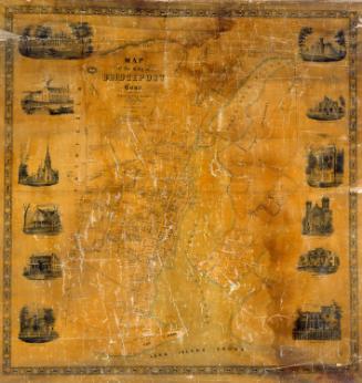
Map of New Haven County
PublisherPublished by
H. & C. T. Smith
American, active1855 - 1856
PublisherCopyrighted by
Robert Pearsall Smith
American, 1827 - 1898
Date1856
MediumLithography; printer's ink and watercolor on wove paper on fabric
DimensionsPrimary Dimensions (image height x width): 53 1/2 x 53 3/4in. (135.9 x 136.5cm)
Sheet (height x width): 58 3/8 x 55 1/2in. (148.3 x 141cm)
Sheet (height x width): 58 3/8 x 55 1/2in. (148.3 x 141cm)
ClassificationsGraphics
Credit LineMuseum purchase
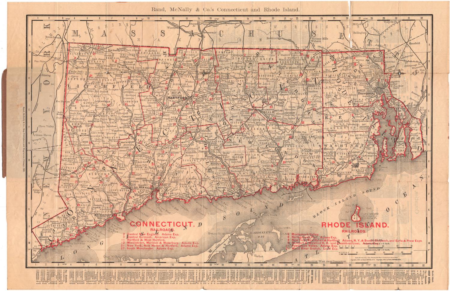
DescriptionMap of New Haven County, Connecticut, with Litchfield County and Hartford County to the north, Middlesex County to the east, Long Island Sound to the south, and Fairfield County to the west. Rivers, ponds, major roads, and railroads are shown. Elevation is indicated by hachure marks. Marshes are indicated by representations of marsh grasses; wooded areas by small trees. Names of property owners are indicated. Locations of court houses, churches, post offices, poor houses, railroad stations, and major businesses are shown. The county map is surrounded by smaller detailed maps of Ansonia, Birmingham, Branford, Cheshire, Derby Narrows, East Haven, Humphreyville (Seymour), Madison, Mayville, Meriden, Milford, Mount Carmel, Naugatuck, New Haven, Wallingford, Waterbury, Waterville, and Westville. Vignettes at left and right overlap the decorative borders to create a trompe-l'oeil effect. Vignettes include Rev. C. W. Everest's Rectory School in Hamden; Residence of Mrs. Whitlock, Southbury; High School, Waterbury; Yale College; Yale College Library; Public Square, New Haven; New York and New Haven Railroad Station; New Haven; Guilford Academy; State Reform School, West Meriden; Town Hall, Meriden; and Residence of John G. North, Oakhill, New Haven. A business directory for New Haven is at upper left. A business directory for Waterbury is at upper right. A table of distances is at upper center. Population statistics are at lower center and agricultural statistics are at lower right.
Object number1986.288.1
MarkingsOn verso, upper right, stamped in blue ink, "CtHi"InscribedOn recto, right center, printed in black ink, "MAP OF / NEW HAVEN / COUNTY ' CONNECTICUT / From actual Surveys / Published by H. & C.Y. SMITH No. 17 & 19 Minor St. / PHILADELPHIA / 1856"; lower right, in black crayon, "#1168 / 57.50"On verso, upper left, in black crayon, "N. H. Co. #769 / 57.50"; upper center, in black ink, "CtHi / 086561"; lower left, in black crayon, "#1168 / 57.50"; lower right, in pencil, "1986.288.1"
NotesCartographic Note: No scale
Collections
- Maps and Charts: Finding Your Place in Connecticut History
On View
Not on view