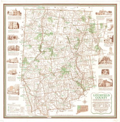
Litchfield County, Connecticut
DraftsmanDrawn by
Vaughn S. Gray
American, 1911 - 1994
PublisherPublished by
Vaughn S. Gray
American, 1911 - 1994
MakerMade by
Kent Stationery
American, active late 20th century
Date1975
MediumLithography; brown and green printer's inks on wove paper
DimensionsPrimary Dimensions (image height x width): 22 x 22in. (55.9 x 55.9cm)
Sheet (height x width): 23 x 23in. (58.4 x 58.4cm)
Sheet (height x width): 23 x 23in. (58.4 x 58.4cm)
ClassificationsGraphics
Credit LineMuseum purchase
DescriptionMap of Litchfield County, Connecticut, from the Massachusetts state line to the north, the Hartford county line to the east, the New Haven and Fairfield county lines to the south, and the New York state line to the west. Towns and cities in the county are labeled, as are such natural features as mountains, ponds, lakes, rivers, and swamps. State parks and forests are denoted in green. Highways and unpaved roads, ski areas, summer camps, camping areas and properties belonging to the Nature Conservancy are also included. The legend, to the bottom left of the map, explains the lines and symbols that represent these features. On the left and right sides of the map are vignettes depicting the Salisbury Town Hall, Gay-Hoyt House, the West Cornwall covered bridge, the Sloane-Stanley Museum, the Kent Memorial Library, the New Milford band stand, the Washington Congregational Church, hte Hitchcock Chair Factory, an example of a turnpike sign, a sketch of the stone walls that line the area, the 1781 mileage marker in Litchfield, the Litchfield Law School, and the Glebe House.
On the verso is a directory of advertisers.
On the verso is a directory of advertisers.
Object number1980.99.0
MarkingsRecto, top and bottom left corners, printed in black ink on stickers: "MAPS / Drawer / 62"Verso, bottom left corner, stamped in blue ink: "THE CONNECTICUT / 81181 / HISTORICAL SOCIETY"InscribedRecto, bottom right, printed in green and brown ink: "LITCHFIELD [in green] / COUNTY [in green] / CONNECTICUT / Herewith a list of the Towns (by date of incorporation or / charter) that did Organize the County of Litchfield in 1751, / choosing Litchfield Town as the County Seat: / Woodbury 1674 New Hartford 1738 Sharon 1739 / New Milford 1712 Canaan 1739 Cornwall 1740 / Litchfield 1719 Goshen 1739 Torrington 1740 / Harwinton 1737 Kent 1739 Salisbury 1741 / Today there are 26 townships, including 2 cities. / This map, showing Points of Interest, Camps, / State Parks, and divers other Informations, / was drawn somewhat by Conjecture / by Yr most Humble and Obedt servant / Vaughn Gray / 1975"
Center, printed in brown ink: "© COPYRIGHT 1975 by Vaughn Gray Box 11 Glendale, Mass. 01229"
Verso, bottom, printed in brown ink: "ADDITIONAL MAPS MAY BE OBTAINED FROM ABOVE ADVERTISERS / Fifty Or More Maps Available From / KENT STATIONERY, KENT, CONN. (927-3043)
Top left, handwritten in pencil: "PRINT / DRAWER / 1C"NotesCartographic Note: Scale: 1/2 inch equals 1 mile
Collections
- Maps and Charts: Finding Your Place in Connecticut History
On View
Not on view