State of Connecticut
SurveyorSurveyed by
Geological Survey (U.S.)
American, founded 1879
PublisherPublished by
Geological Survey (U.S.)
American, founded 1879
Date1967
MediumColor lithography; colored printer's ink on wove paper
DimensionsPrimary Dimensions (image height x width): 41 3/4 x 54in. (106 x 137.2cm)
Sheet (height x width): 44 1/2 x 56 1/2in. (113 x 143.5cm)
Sheet (height x width): 44 1/2 x 56 1/2in. (113 x 143.5cm)
ClassificationsGraphics
Credit LineConnecticut Museum of Culture and History collection
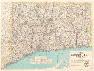
DescriptionTopographical (contour) map of Connecticut and Long Island Sound, with latitude and longitude lines and coordinates. The legend provides information about the features found on the map. Color is used to denote built-up areas, state parks and state forests. Interstate highways, U.S. highways, state highways and other roads are marked with lines of varying widths, and the names of cities are sized according to population. Town names are also given, with broken lines separating towns and counties. The three bordering states, New York, Massachusetts and Rhode Island, are named on the map but no geographical or political features are given.
Object number2012.312.106
InscribedRecto, bottom right, printed in black ink: "UNITED STATES / DEPARTMENT OF THE INTERIOR / GEOLOGICAL SURVEY / STATE OF CONNECTICUT"Bottom right, printed in black ink: Scale 1:125,000 / 1 inch equals approximately 2 miles"
Bottom right, printed in black ink: "Contour interval 50 feet [in brown ink] / Datum is mean sea level"
Bottom right, printed in black ink: "Compiled, edited, and published by the Geological Survey in cooperation with State of Connecticut agenies / 1927 North American datum. Polyconic projection"
Bottom right, printed in black ink: "SOURCE DATA / U.S. Dept. of the Interior - Geological Survey topographic maps"
Bottom right, printed in black ink: "BASE MAP / WITH HIGHWAYS [in red ink] / AND CONTOURS [in brown ink]"
Bottom right, printed in black ink: "FOR SALE BY U.S. GEOLOGICAL SURVEY, WASHINGTON, D.C. 20242 / COMPILED IN 1965 / EDITION OF 1966"
Bottom right, printed in black ink: "INTERIOR--GEOLOGICAL SURVEY, WASHINGTON, D.C. -- 1967 / CONNECTICUT"NotesCartographic Note: Scale: 1:125,000; 1 inch = approximately 2 miles
Collections
- Maps and Charts: Finding Your Place in Connecticut History
On View
Not on view