Map of Connecticut
MakerCopyrighted by
Connecticut Department of Transportation
American, founded 1969
PublisherPublished by
Connecticut Development Commission
American, founded 1939
PublisherPublished by
State Park and Forest Commission
American, 1921 - 1971
PublisherPublished by
State Board of Fisheries and Game
American, 1913 - 1971
Date1971
MediumOffset lithography; black and colored printer's inks on wove paper
DimensionsPrimary Dimensions (image height x width): 23 1/8 x 35 1/4in. (58.7 x 89.5cm)
Sheet (height x width): 23 7/8 x 36in. (60.6 x 91.4cm)
Sheet (height x width): 23 7/8 x 36in. (60.6 x 91.4cm)
ClassificationsGraphics
Credit LineConnecticut Museum of Culture and History collection
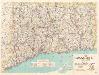
DescriptionRoad map of the state of Connecticut, including the Long Island Sound, with grid letters at the top and bottom and numbers on both sides. Degrees of longitude and latitude are provided, as well. The legend at the bottom of the sheet provides information about the types of roads marked on the map; interstates, US routes and state routes and their symbols; the political boundary lines for states, towns and counties; symbols marking yacht clubs, airports, heliports and boat launching sites; circles of varying sizes for cities of differing populations; and the scale. There is also a list of public boat launching sites, and an index of cities, towns and places, with their grid coordinates provided. The compass rose, located to the left of the legend, features a shield with three grapevines in it and the Latin phrase "Qui Transtulit Sustinet," which means "He who transplanted still sustains." To the right and at the bottom are inset maps of Waterbury/Naugatuck, Torrington, Ansonia/Derby/Shelton, Meriden, Middletown, Wallingford, Willimantic, New Haven, Bristol/New Britain, Hartford, Norwich, New London/Groton, Bridgeport, Danbury, Stamford/Norwalk, and Greenwich.
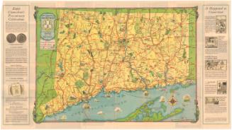
On the back are photographs illustrating seasonal activities, scenery, history, fun activities, state parks, and hunting and fishing. The Charter Oak Trail is depicted on an outline map of the state. Information about public recreation areas and their features, toll roads, ferries, rest areas, signage, highway safety and emergencies is provided on the right, along with a distance table.
On the back are photographs illustrating seasonal activities, scenery, history, fun activities, state parks, and hunting and fishing. The Charter Oak Trail is depicted on an outline map of the state. Information about public recreation areas and their features, toll roads, ferries, rest areas, signage, highway safety and emergencies is provided on the right, along with a distance table.
Object number2004.154.0
MarkingsVerso, top right, stamped in black ink: "Connecticut Historical Society / Library"InscribedRecto, top left, printed in black ink: "1971 / MAP OF Connecticut"Top left, printed in black ink: "Copyright, / The Connecticut / Department of / Transportation"
Verso, top right, in white text on blue background: "1971 / MAP OF / CONNECTICUT"
Top right, in white text on blue background: "CONNECTICUT DEPARTMENT OF TRANSPORTATION / CONNECTICUT DEVELOPMENT COMMISSION / STATE PARK AND FOREST COMMISSION / STATE BOARD OF FISHERIES AND GAME"
Top right, handwritten in pencil: "98622"
Center right, handwritten in pencil: "MAPS / Shelf / 98622"NotesCartographic Note: Scale: 1 inch equals 1 1/2 miles
Collections
- Maps and Charts: Finding Your Place in Connecticut History
On View
Not on view