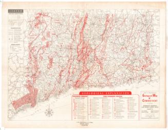
The Connecticut Guide Map
PublisherPublished by
Emergency Relief Commission
American, 1933 - 1937
Date1935
MediumLithography; black and colored printer's inks on wove paper
DimensionsPrimary Dimensions (image height x width): 28 3/4 x 38 7/8in. (73 x 98.7cm)
Sheet (height x width): 30 1/8 x 40in. (76.5 x 101.6cm)
Sheet (height x width): 30 1/8 x 40in. (76.5 x 101.6cm)
ClassificationsGraphics
Credit LineGift of Martin A. Gilman
DescriptionMap of Connecticut, from the border of Massachusetts to the north, Rhode Island to the east, the north shore of Long Island and the Long Island Sound to the south, and New York State to the west. Four- and two-lane state roads are depicted in red, with four- and two-lane state aid roads in green and unimproved state roads in red and white. Other roads are shown as two parallel lines, and scenic roads as parallel lines with black dots between them. U.S. and state highways are numbered. Other kinds of transportation infrastucture depicted include ferry routes, railroads, airports and lighthouses. The locations of "scenic places" and "good views" are denoted with symbols, as are historic buildings, forts and battlefields, sites of Native American history and industrial history, old mines and quarries, and areas of geological or botanical interest. The sizes of the names of cities correspond to their population, with larger cities appearing in larger type.
Object number2001.192.1
MarkingsVerso, right side, stamped in black ink: "Connecticut Historical Society / Library"InscribedRecto, bottom right, printed in black ink: "THE / CONNECTICUT / GUIDE MAP / A / PROJECT OF / THE STATE PLANNING BOARD / INITIATED UNDER CWA & COMPLETED WITH FERA FUNDS / Published by / Emergency Relief Commission / Hartford, Connecticut - 1935"Verso, right side, handwritten in pencil: "97353"
Recto of brown paper envelope: "The / State of [handwritten in blue ink] / CONNECTICUT / GUIDE / MAP / 1935 [handwritten in blue ink] / A Project of The / STATE PLANNING BOARD / Published By / The / EMERGENCY RELIEF COMMISSION"
NotesCartographic Note: Scale: 3/8 inches equals 1 mile
Collections
- Maps and Charts: Finding Your Place in Connecticut History
On View
Not on view
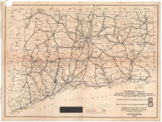
Connecticut State Highway Department
1923