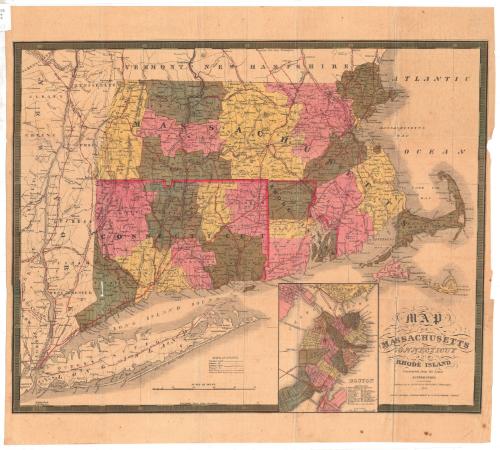
Map of Massachusetts, Connecticut and Rhode Island
PublisherPublished by
Samuel Augustus Mitchell
1792 - 1868
RetailerSold by
Thomas, Cowperthwait & Co.
American, 1849 - 1854
Date1847
MediumLithography; black printer's ink and watercolor on wove paper
DimensionsPrimary Dimensions (image height x width): 17 1/4 x 21 5/8in. (43.8 x 54.9cm)
Sheet (height x width): 20 1/4 x 22 3/8in. (51.4 x 56.8cm)
Sheet (height x width): 20 1/4 x 22 3/8in. (51.4 x 56.8cm)
ClassificationsGraphics
Credit LineMuseum purchase
DescriptionMap of Massachusetts, Connecticut and Rhode Island, with Vermont and New Hampshire to the north, the Atlantic Ocean to the east, Long Island and the Long Island Sound to the south, and New York to the west. Counties are delineated with broken solid lines and are colored pink, yellow or green. Towns are delineated with thin dotted lines. Smaller cities are marked with open circles and larger ones with closed circles. An inset map of Boston appears to the left of the cartouche, showing the locations of 20 notable buildings; various public buildings; and places of worship. Various methods of transportation are depicted, including principal roads, common roads, existing canals, proposed canals, railroads and proposed railroads.
The railroads shown include the New York and New Haven (existing); Hudson River (proposed); New York and Harlem (proposed); Albany and Stockbridge (existing); Housatonic (existing); Western (existing); New York and Boston (proposed); New Haven and Springfield (existing); what is probably the New London, Willimantic and Palmer (proposed); Norwich and Worcester (existing); Stonington (existing); Worcester (existing); Vermont and Massachusetts (existing); Fitchburg (existing); Boston and Lowell (existing); Boston and Maine (existing); Old Colony (existing); Fall River (existing); and Eastern (existing). The Farmington; Hampshire and Hampden; and Blackstone are the existing canals shown. A proposed canal leading to Taunton, Massachusetts, is also depicted.
Physical features depicted include elevation, conveyed with clusters of peaks; lakes; and islands.
Object number1953.72.0
MarkingsRecto, top left corner, printed in black ink on sticker: "MAPS / Box / 244"Verso, center, stamped in blue ink: "CtHi"InscribedRecto, bottom right, printed in black ink: "MAP / OF / MASSACHUSETTS / CONNECTICUT / AND / RHODE ISLAND / Constructed from the Latest / AUTHORITIES. / Published by S. AUGUSTUS MITCHELL Philadelphia. / 1847 / SOLD BY THOMAS, COWPERTHWAIT & Co. No. 255 MARKET STREET."
Verso, top left, handwritten in pencil: "Maps / Flat / 49"
Center, handwritten in pencil: "62075"
Right side, handwritten in pencil: "62075"NotesCartographic Note: Scale, main map: 1/2 inch equals about 5.5 miles; scale, inset map of Boston: 1/4 inch equals about 550 feet
Collections
- Maps and Charts: Finding Your Place in Connecticut History
On View
Not on view


H. F. Sumner & Co.
1833


H. F. Sumner & Co.
1833


