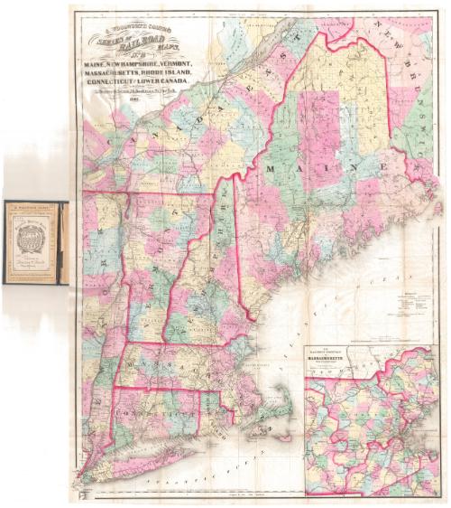
Maine, New Hampshire, Vermont, Massachusetts, Rhode Island, Connecticut and Lower Canada
PublisherPublished by
George W. Colton
American, 1827 - 1901
Date1861
MediumLithography; black printer's ink and watercolor on wove paper, in cardboard covers
DimensionsPrimary Dimensions (image height x width): 35 x 26in. (88.9 x 66cm)
Sheet (height x width): 35 3/4 x 26 3/4in. (90.8 x 67.9cm)
Sheet (height x width): 35 3/4 x 26 3/4in. (90.8 x 67.9cm)
ClassificationsGraphics
Credit LineGift of Charles H. Clark
DescriptionPocket map of the New England states, Canada East (modern-day Quebec) and New Brunswick. Red lines mark the divisions between the states and parts of Canada, and the areas are further divided into counties or townships, colored pink, blue, yellow or green. The main focus of the map is the network of railroads in the region, with both existing and under-construction railroads shown. Stations are marked with open circles, and the distance between stations is provided. The existing lines depicted include the Grand Trunk; Vermont Central; Hudson River; New York and Harlem; New York and New Haven; Housatonic; Western; Canal; New London Northern; Norwich and Worcester; New York, Providence and Boston; Boston, Concord and Montreal; Vermont and Massachusetts; Boston and Worcester; Worcester and Providnece; Cape Cod; Portland, Saco and Portsmouth; and Kennebec and Portland. Lines under construction include the New York and Boston. In the lower right corner is an inset map of eastern Massachusetts. Physical features depicted include elevation, conveyed with hachure marks; rivers; and lakes.
Object number1893.17.1
MarkingsInside cover, printed in black ink on labeled: "Connecticut Historical Society / No. 7331 ["7331" handwritten in red ink] / PRESENTED BY / Charles H. Clark [handwritten in black ink] / Hartford [handwritten in black ink]"InscribedFront cover, gold tooled: "G. Woolworth Colton's / SERIES OF / Rail Road / MAPS / No 2 / MAINE., N.H., VT., MASS, / R.I., CONN., LR. CANA. &c"Inside cover, top left, handwritten in red ink: "7331"
Top right, handwritten in pencil: "Maps / 7331"
Top, printed in black ink: "G. WOOLWORTH COLTON, / GEOGRAPHER TO THE LATE FIRM OF J.H. COLTON & CO., AND AUTHOR OF / COLTON'S ATLASES, MAPS, ETC."
Recto of map, top left, printed in black ink: "G. WOOLWORTH COLTON'S / SERIES OF / RAILROAD / MAPS, / NO. 2 / MAINE, NEW HAMPSHIRE, VERMONT, / MASSACHUSETTS, RHODE ISLAND, / CONNECTICUT AND LOWER CANADA. / PUBLISHED BY / G. Woolworth Colton, 18. Beekman St. New York. / 1861"
Bottom, printed in black ink: "Entered according to Act of Congress in the Year 1860 by G. Woolworth Colton, in the Clerks Office of the District Court of the United States, for the Southern District of New York."
NotesCartographic Note: Scale: 1 inch equals 14.2 miles
Subject Terms
- Connecticut
- Massachusetts
- Rhode Island
- Vermont
- Maine
- New Hampshire
- Hartford, Providence, and Fishkill Railroad Company
- Naugatuck Railroad
- Norwich and Worcester Railroad Company
- Railroads
- New York and New Haven Railroad Company
- Lithographs
- Regional Maps
- Railroad Maps
- Relief Maps
- Map Cataloging Project
- New England
- Quebec
- New Brunswick
Collections
- Maps and Charts: Finding Your Place in Connecticut History
On View
Not on view


Matthews-Northrup Company
1913