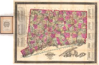
Rail Road Map of New England, Canada & Eastern N.Y. Compiled from the most authentic sources
DraftsmanDrawn by
J. H. Goldthwait
American
PublisherPublished by
Redding & Co.
American, founded before1843
Date1850
MediumLithography; black printer's ink and watercolor on paper
DimensionsPrimary Dimensions (image height x width): 24 x 19 3/4in. (61 x 50.2cm)
Sheet (height x width): 26 5/8 x 20 5/8in. (67.6 x 52.4cm)
Sheet (height x width): 26 5/8 x 20 5/8in. (67.6 x 52.4cm)
ClassificationsGraphics
Credit LineConnecticut Museum of Culture and History collection
DescriptionMap of the New England states and part of New York State along the Hudson River. An inset map in the lower right corner depicts northern New England and part of Quebec. The state borders are outlined in pink and are further divided into counties, labeled and colored pink, blue or yellow; and towns, labeled and outlined in solid lines. The railroad lines depicted on the map include the Long Island; New York and New Haven; New Haven and Hartford; Canal; Housatonic; Naugatuck; Norwich and Worcester; Stonington; Harlem; Berkshire; Western; Connecticut River; Massachusetts; Providence and Worcester; Bedford and Taunton; Boston and Worcester; Fitchburg; Boston and Lowell; New Hampshire Central; Rutland; Portland, Saco and Portsmouth; St. Lawrence and Atlantic; Vermont Central; and Washington and Saratoga Railroads.
Object number2012.312.147
MarkingsRecto, bottom right corner, printed in black ink on sticker: "Maps / Book / 13"InscribedRecto, right side, printed in black ink: "RAIL ROAD MAP / OF / NEW ENGLAND, / CANADA & EASTERN N.Y. / Compiled from the most authentic sources / By J.H. Goldthwait / 1850."Center bottom, printed in black ink: "BOSTON: / PUBLISHED BY REDDING & CO. / 1850."
Bottom left, printed in black ink: "Entered according to Act of Congress in the year 1850 by Redding & Co. in the Clerks Office of the District Court of the United States for the District of Massachusetts"NotesCartographic Note: Scale: About 1 inch equals 10 miles
Bibliographic Note: An 1849 edition of this map is illustrated in DavidRumsey.com. That map is a folding pocket map, a format that would have been especially useful to railroad travelers.
Collections
- Maps and Charts: Finding Your Place in Connecticut History
On View
Not on view