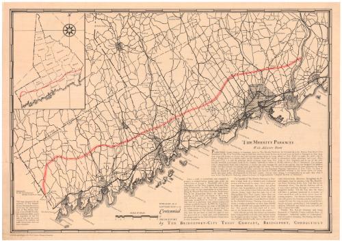
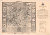
The Merritt Parkway with Adjacent Roads
PublisherPublished by
Bridgeport City Trust Company
American
Date1936
MediumLithography; black and red printer's ink on wove paper
Offset lithography; black printer's ink on wove paper
DimensionsPrimary Dimensions (image height x width): 15 1/8 x 21 3/4in. (38.4 x 55.2cm)
Sheet (height x width): 16 x 22 3/4in. (40.6 x 57.8cm)
Sheet (height x width): 16 x 22 3/4in. (40.6 x 57.8cm)
ClassificationsGraphics
Credit LineGift of the Bridgeport City Trust Co.
DescriptionMap of the Merritt Parkway as it runs through coastal Connecticut, from where it connects with the Hutchinson River Parkway in New York State to the Housatonic River. The Parkway is depicted as three red lines, with other roads, such as U.S. 1, denoted with thick black lines. The major roads are labeled. Smaller roads are shown with thin black lines and are unlabeled. Towns are divided with broken solid lines. Cities are denoted with crosshatching. The natural features along the Long Island Sound, such as islands and points, are labeled. In the top left corner is an inset map that shows the Merritt Parkway without any other roads. Below the maps is a history of the Merritt Parkway's design and a description of what improvements it would bring to the region.
On the back of the map is a reproduction of a 1795 map of Bridgeport, Connecticut. To the right is the Bridgeport-City Trust Company's "Monthly Report to Customers" for May 1936, which includes a description of what Bridgeport was like in 1836. Below this is a "Condensed Statement of Condition," which outlines the bank's assets and liabilities.
On the back of the map is a reproduction of a 1795 map of Bridgeport, Connecticut. To the right is the Bridgeport-City Trust Company's "Monthly Report to Customers" for May 1936, which includes a description of what Bridgeport was like in 1836. Below this is a "Condensed Statement of Condition," which outlines the bank's assets and liabilities.
Object number1936.31.0
MarkingsVerso, right side, stamped in blue ink: "CtHi"InscribedRecto, right side, printed in black ink: "THE MERRITT PARKWAY / With Adjacent Roads"Bottom, printed in black ink: "PUBLISHED AS A / CONTRIBUTION to the / Centennial / of / BRIDGEPORT / by THE BRIDGEPORT-CITY TRUST COMPANY, BRIDGEPORT, CONNECTICUT"
Bottom left, printed in black ink: "This map, prepared with the / assistance of The Fairfield / County Planning Association, / shows only the approximate / route of The Merritt Park- / way across Fairfield County, / since at this date (May, 1936) / the acquisition of land for / right of way and the actual / location of the roadway and / traffic intersections have not / been completed."
Bottom left, printed in black ink: "Copyright, 1936, Bridgeport-City Trust Company, Bridgeport, Connecticut"
Verso, top left, handwritten in red ink: "46460"
Top right, printed in black ink: "Monthly Report to Customers / May 1936"
Right side, printed in black ink: "CONDENSED STATEMENT OF CONDITION / The / Bridgeport-City Trust Company / BRIDGEPORT, CONN. / At the Close of Business April 30, 1936"
Bottom left, printed in black ink: "1836 BRIDGEPORT 1936"NotesCartographic Note: Scale: About 1 1/8 inches equals 2 miles
Collections
- Maps and Charts: Finding Your Place in Connecticut History
On View
Not on view


Natural Color Cards Co.