Connecticut Recreational Areas and Facilites
MakerCopyrighted by
National Survey Co.
American, founded 1912
PublisherPublished by
State Park and Forest Commission
American, 1921 - 1971
PublisherPublished by
State Board of Fisheries and Game
American, 1913 - 1971
PhotographerPhotographs by
Josef Scalyea
Italian-American, 1913 - 2004
Date1945
MediumOffset lithography; black and colored printer's inks on wove paper
DimensionsPrimary Dimensions (image height x width): 19 3/8 x 27in. (49.2 x 68.6cm)
Sheet (height x width): 20 x 31 1/2in. (50.8 x 80cm)
Sheet (height x width): 20 x 31 1/2in. (50.8 x 80cm)
ClassificationsGraphics
Credit LineConnecticut Museum of Culture and History collection
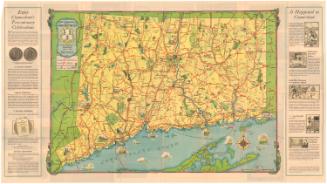
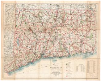
DescriptionFolding map of the state of Connecticut, including the Long Island Sound. The map shows state parks, colored red, and state forests, colored green, both of which are also listed in the key on the left side. Cities are labeled and denoted with circles of varying sizes according to population. Regulated streams are marked with broken red lines, regulated hunting grounds with yellow stars, and regulated lakes and ponds in brown. Highways, local roads and railroads are shown. Highway picnic areas and monuments are marked with red symbols. Also on the left side of the sheet are drawings of of the outdoor activities Connecticut offers: boat, camping, visiting historic sites, picnicking, swimming, hiking trails, visiting view points, and participating in winter sports.
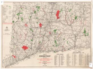
On the back, there are black-and-white photographs of the state's parks and forests, a map of Connecticut with parks marked with circles and forests marked with triangles, a mileage chart listing towns and their distances from the parks and forests, and information about hunting and fishing.
On the back, there are black-and-white photographs of the state's parks and forests, a map of Connecticut with parks marked with circles and forests marked with triangles, a mileage chart listing towns and their distances from the parks and forests, and information about hunting and fishing.
Object number2004.162.0
MarkingsVerso, bottom right, stamped in black ink: "Connecticut Historical Society / Library"InscribedRecto, top left, handwritten iin pencil: "MAPS / Shelf / 98717"Bottom right, printed in black ink: "CONNECTICUT / RECREATIONAL AREAS / and / FACILITIES / 1945"
Bottom right, printed in black and red ink: [National Survey Company logo]
Bottom right, printed in black ink: "COPYRIGHT, NATIONAL SURVEY CO., CHESTER, VT."
Verso, top right, in yellow on black and white background: "CONNECTICUT / STATE PARKS / FORESTS / 1945"
Top right, in yellow on black and white background: "Administered by / The State Park & / Forest Commission / and the / State Board of / Fisheries & Game"
Bottom right, printed in black ink: "Photographs Courtesy of / Dr. G. H. Ludins, West Hartford, Conn., and / Connecticut State Development Commission / (Dgt. J. Scalyea, Photographer)"
Bottom right, handwritten in pencil: "98717"NotesCartographic Note: Scale: 13/16 inch equals 4 miles
Collections
- Maps and Charts: Finding Your Place in Connecticut History
On View
Not on view


Connecticut State Highway Department
1934