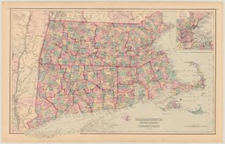
The National Publishing Company's Railroad, Post Office, Township and County Map
PublisherPublished by the
National Publishing Company
American, before 1873 - after 1919
Date1902
MediumLithography; colored printer's inks on wove paper mounted on fabric
DimensionsPrimary Dimensions (image height x width): 35 1/4 x 37 1/4in. (89.5 x 94.6cm)
Sheet (height x width): 38 x 39in. (96.5 x 99.1cm)
Sheet (height x width): 38 x 39in. (96.5 x 99.1cm)
ClassificationsGraphics
Credit LineConnecticut Museum of Culture and History collection
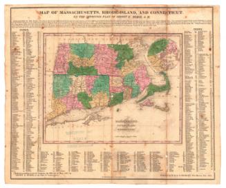
DescriptionMap of Massachusetts, Connecticut, and Rhode Island, with Vermont, New Hampshire, and Maine to the north, the Atlantic Ocean to the east, Long Island Sound and part of Long Island to the south, and New York State to the west. Counties are shown in different colors and the same colors are used to outline the townships within each county. Many hills, mountains, rivers, streams and other geographical features are shown and named. Elevation is indicated by hachure marks. Railroads, steamship lines and mailboat routes are clearly shown, but highways and other roads are not included. A small map of the United States showing political divisions is at lower right. Tables list travel distances between major cities; counties and county seats; and population in each census between 1800 and 1900. An index to cities and towns is at upper right with coordinates corresponding to letters in the upper and lower margins and numbers in the left and right margins.
Object number2012.312.302
MarkingsOn verso, upper left, on gummed label, typed in black ink, "MAPS / Box 5 / No. 12"On verso, upper right, on gummed label, typed in black ink, "MAPS / Box 5 / No. 12"InscribedOn recto, upper left, in black ink, "NATIONAL PUBLISHING COMPANY'S RAILROAD / POST OFFICE, TOWNSHIP AND / COUNTY MAP OF / MASSACHUSETTS, / RHODE ISLAND AND CONNECTICUT. / WITH DISTANCES / IN / FIGURES / COMPILED FROM / THE LATEST / GOVERNMENT SURVEYS / AND ORIGINAL / SOURCES / Price $3.00. / PUBLISHED BY THE NATIONAL PUBLISHING CO., BOSTON, MASS. - COPYRIGHT, 1902, THE NATIONAL PUBLISHING CO., BOSTON, MASS."; upper left corner, in black ink, "No. 827"
On verso, upper left, in pencil, "MAPS / Box 5 / No. 12"
On verso, upper right, in pencil, in pencil, "MAPS / Box 5 / No. 12"
On verso, lower right, in pencil, "2012.312.302"NotesCartographic Note: Approximately five miles to one inch
Collections
- Maps and Charts: Finding Your Place in Connecticut History
On View
Not on view