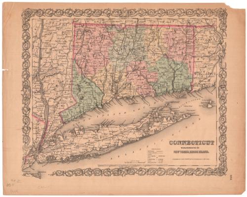
Conneticut with Portions of New York and Rhode Island
PublisherPublished by
J. H. Colton & Co.
American, founded 1831
Date1855
MediumLithography; black printer's ink and watercolor on wove paper
DimensionsPrimary Dimensions (image height x width): 12 3/4 x 15 1/2in. (32.4 x 39.4cm)
Sheet (height x width): 14 5/8 x 18 3/8in. (37.1 x 46.7cm)
Sheet (height x width): 14 5/8 x 18 3/8in. (37.1 x 46.7cm)
ClassificationsGraphics
Credit LineConnecticut Museum of Culture and History collection
DescriptionMap of Connecticut with Long Island and the eastern portion of New York State, and the western portion of Rhode Island. The borders of all three states are colored dark pink, but only Connecticut's counties are colored (pink, blue, yellow and green). The names of the states' counties are printed in capital letters. Connecticut is further divided into towns. Cities are represented by open circles for towns and closed circles within circles for county towns. Villages are represented with open circles and are labeled in italics. Railroads and common roads are depicted with different lines. The Long Island; New York and Harlem; Hudson; New York and New Haven; Housatonic; Naugatuck; New Haven and Northampton; Hartford, Providence and Fishkill; New Haven, Hartford and Springfield; New London, Willimantic and Palmer; and Stonington and Providence Railroads are the lines shown on the map. The explanation at the bottom of the sheet has an entry for canals, although the area where showing the line used to indicate canals is blank. Elevation is conveyed through hachure marks.
Object number2006.138.0
MarkingsVerso, center, stamped in blue ink: "CtHi"InscribedRecto, bottom right, printed in black ink: "CONNECTICUT / WITH PORTIONS OF / NEW YORK & RHODE ISLAND. / PUBLISHED BY J.H. COLTON & Co. No. 172 WILLIAMS St. NEW YORK."Bottom right, printed in black ink: "30"
Bottom right, printed in black ink: "No. 14."
Bottom center, printed in black ink: "Entered According to Act of Congress in the Year 1855, by J.H. Colton & Co. in the Clerk's Office of the District Court of the United States for the Southern District of New York"
Bottom left, handwritten in pencil: "No II"
Bottom left, handwritten in pencil: [illegible]
Bottom left, handwritten in pencil: "1955" [?]
Bottom left, handwritten in pencil: "[99607]"
Verso, top left corner, handwritten in pencil: "Print / Drw 2 / #34"NotesCartographic Note: Scale: 1/2 inch equals 5 miles
Collections
- Maps and Charts: Finding Your Place in Connecticut History
On View
Not on view