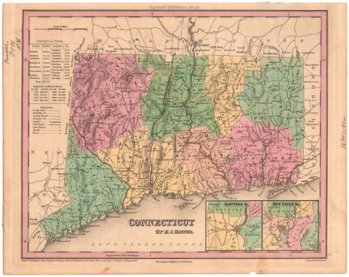
Connecticut
PublisherPublished by
Henry Schenck Tanner
American, 1786 - 1858
PrintmakerEngraved by
E. B. Dawson
American
Date1834
MediumEngraving; black printer's ink and watercolor on wove paper
DimensionsPrimary Dimensions (image height x width): 11 3/8 x 13 15/16in. (28.9 x 35.4cm)
Platemark (width only): 14 3/4in. (37.5cm)
Sheet (height x width): 12 3/8 x 15 5/8in. (31.4 x 39.7cm)
Platemark (width only): 14 3/4in. (37.5cm)
Sheet (height x width): 12 3/8 x 15 5/8in. (31.4 x 39.7cm)
ClassificationsGraphics
Credit LineBarbour Fund
DescriptionMap of the state of Connecticut, with the border of Massachusetts to the north, Rhode Island to the east, the Long Island Sound to the south, and New York to the west. The state is divided into counties, which are labeled and delineated with broken solid lines, and towns, which are also labeled and delineated with solid lines. "Leading roads," common roads, canals and railroads are the transportation routes shown, marked with different lines. The locations of courthouses, churches and taverns are also shown and marked with different symbols. Natural features include elevation, conveyed with hachure marks, ponds and lakes, islands and points. In the bottom right corner are two inset maps of Hartford and New Haven. To the left of the map is a statistical table containing information about the populations of various counties and towns in Connecticut, as well as historical population data.
Object number1943.10.2
InscribedRecto, top center, printed in black ink: "TANNER'S UNIVERSAL ATLAS."Top left, handwritten in pencil: "Tanner / P774 / 1836"
Right side, handwritten in pencil: "16 3/4 x 19 1/4"
Bottom center, printed in black ink: "CONNECTICUT / BY H.S. TANNER."
Bottom left, printed in black ink: "Entered according to Act of Congress, in the year 1834, by H.S. Tanner, in the Clerks Office of the Eastern District of Pennsylvania"
Bottom center, printed in black ink: "Philadelphia: Published by H.S. Tanner."
Bottom right, printed in black ink: "Engraved by E.B. Dawson"
Verso, top left, handwritten in red ink: "54376"
Center, handwritten in pencil: "54376"
Bottom left, handwritten in pencil: "MAP BOX / 6"
Bottom right, handwritten in pencil: "54376"NotesCartographic Note: Scale: 9/15 inches equals 5 miles
Collections
- Maps and Charts: Finding Your Place in Connecticut History
On View
Not on view


H. F. Sumner & Co.
1833