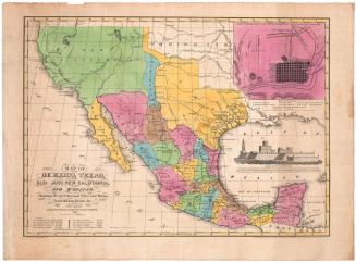
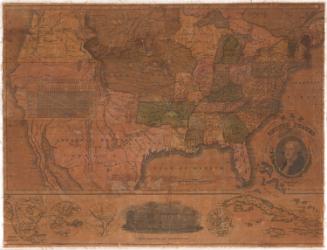
Map of the United States with the contiguous British and Spanish Possessions
DraftsmanEngraved by
Henry Schenck Tanner
American, 1786 - 1858
PrintmakerEngraved by
John Vallance
American, 1770 - 1823
PublisherPublished by
John Melish
Scottish, 1771 - 1822
Date1822
MediumEngraving; black printer's ink and watercolor on paper
DimensionsPrimary Dimensions (image height x width): 43 x 56 3/4in. (109.2 x 144.1cm)
Sheet (height x width): 45 1/8 x 58 1/8in. (114.6 x 147.6cm)
Sheet (height x width): 45 1/8 x 58 1/8in. (114.6 x 147.6cm)
ClassificationsGraphics
Credit LineConnecticut Museum of Culture and History collection
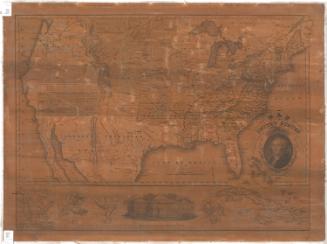
DescriptionMap of North America, extending from Upper Canada to the north, the Atlantic Ocean to the east, Guatemala and the Yucatan peninsula to the south, and New California to the west. State and territorial boundaries are outlined in broken/dotted lines and color, and towns are marked with circles. Physical features include rivers and mountains. Exploration routes and roads are also included as double-solid lines; roads are marked with distances in miles between points. An inset map of the West Indies is found in the lower right corner. In the lower left corner, there is a statistical table with extent, area and population information about the countries, states and territories depicted on the map. Degrees of latitude and longitude are marked inside the borders. The cartouche feagures a bald eagle holding an olive branch in its right talon and a bundle of arrows in its left, with its head turned toward the left. In its beak, it holds a ribbon bearing a shield featuring thirteen stripes and nineteen stars. Above the eagle's head, the ribbon is inscribed with the Latin "E pluribus unum," "Out of many, one."
Object number2012.312.177
MarkingsRecto, lower left corner, printed in black ink on sticker: "MAPS / Oversize / Drawer / 4"InscribedRecto, right, printed in black ink: "SCALE of MILES 60 to an inch / The Figures along the Roads denote the Distances"Right, printed in black ink: "MAP / of the / United States / with the contiguous / BRITISH & SPANISH POSSESSIONS / Compiled from the latest & best Authorities / BY / John Melish / Engraved by J. Vallance & H.S. Tanner"
Right, printed in black ink: "ENTERED according to Act of CONGRESS the 16th day of June 1820. / Published by John Melish Philadelphia / Improved to 1822."NotesCartographic Note: Scale: 1 inch equals 60 miles
Collections
- Maps and Charts: Finding Your Place in Connecticut History
On View
Not on view