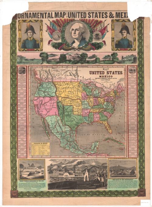
Ornamental Map of the United States & Mexico
PrinterPrinted by
Ensign & Thayer
American, 1849 - 1850
PublisherPublished by
Ensign & Thayer
American, 1849 - 1850
WriterVignette text written by
Rufus Blanchard
American, 1822 - 1904
Date1848
MediumLithography; printer's ink and watercolor on wove paper
DimensionsPrimary Dimensions (image height x width): 29 1/8 x 21in. (74 x 53.3cm)
Sheet (height x width): 31 3/4 x 23 1/8in. (80.6 x 58.7cm)
Sheet (height x width): 31 3/4 x 23 1/8in. (80.6 x 58.7cm)
ClassificationsGraphics
Credit LineConnecticut Museum of Culture and History collection
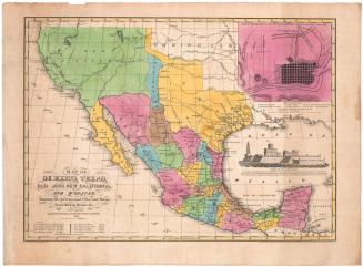
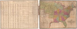
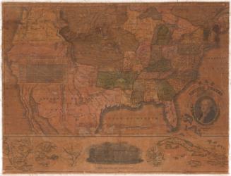
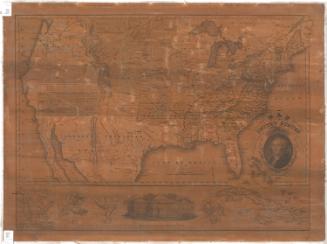
DescriptionMap of the United States, Mexico, part of Guatemala and part of the Caribbean islands, from the border of Canada to the north, the Atlantic Ocean to the east, Guatemala to the south, and the Pacific Ocean to the west. The states, including those of Mexico, and countries are outlined in red and colored pink, green or yellow. In the bottom left corner of the map is a list of distances in Mexico. Two columns, one on either side of the map, list the 32 states and territories comprising the United States and provide statistics for each entry on the settlement date, the country settled by, the year admitted into the Union, the population, capital and the population of the capital. The bottom and sides are decorated with a border of stars linked by chains, and at all four corners, there is a shield featuring stars and stripes.
Right above the map, there is a panoramic image from New York to the Pacific Ocean "by the Contemplated Oregon Railroad." The picture is bookended by similar scenes depicting ships sailing off of a coast and in a harbor surrounded by busy factories, respectively. The other scenes show the Rocky Mountains, and what appears to be a university building.
Along the top of the sheet, right below the title, there are three vignettes, with images of General Taylor and General Scott flanking a larger portrait of Washington. The frames around the generals contain various symbols: oak leaves and acorns; shields with a single star and eleven stripes; and two unidentified monuments, one of which appears to be the Washington Monument. Around Washington's portrait are mirror images featuring leafy oak branches laden with acorns, cornucopias or horns of plenty, liberty caps, and the American flag. On the right side of the portrait is a banner that says "Liberty" and the seal of Mexico; on the left, there is a banner that says "Justice" and the reverse of the Great Seal of the United States.
Below the map, there are three more vignettes. On the left, there is an image of Templo Mayor, an Aztec temple, with text describing its physical features and use; on the right is an image of Chapultepec Castle, with accompanying text about the "Halls of Montezuma." In the center, there is a much larger image of a man in fashionable dress, lecturing to the "sovereigns of Europe" about the progress of American shipping, farming, manufacture and exploration.
Object number2012.312.103
InscribedRecto, top, printed in black ink: "ORNAMENTAL MAP OF THE UNITED STATES & MEXICO"Top center, printed in black ink: "Panoramic View from NEW YORK to the PACIFIC OCEAN by the Contemplated OREGON RAILROAD."
Inside the map image area, right, printed in black ink: "MAP / OF THE / UNITED STATES / AND / MEXICO / Including OREGON, TEXAS and the / CALIFORNIAS"
Bottom right, printed in black ink: "GREAT TEMPLE DEDICATED TO THE SUN. / DESTROYED BY CORTEZ IN 1521. / This Temple was finished and dedicated in 1486. It was a place of worship and human sac- / rifice. Sixty thousand victims perished at its dedicated, and every part of it was bathed in / human blood. It occupied the centre of the city, now the Great Square. It was a triple Pyra- / mid, with a place for sacrifice on the top. It was surrounded by a stone wall eight feet thick, / crowned with battlements and ornamented with figures in the form of Serpents. The interior / of the enclosure was paved with polished Porphyry, and was spacious enough to contain five / hundred Houses. The wall had four gates, and over each was a military Arsenal. From the / centre arose the great TEOCALLIS, or Temple. The great Cathedral now occupies its place. / RUFUS BLANCHARD, CINCINNATI. / JOS. WARD, 52 CORNHILL ST., BOSTON."
Bottom left, printed in black ink: ""THE HALLS OF THE MONTEZUMAS." / If we may believe the glowing accounts of Clavigero and other early Spanish writers, concerning the / wealth and magnificence of Montezuma, the last of the ancient Mexican sovereigns, the splendor and / pageantry of his court rivalled that of Eastern monarchs, famed in history and romance. The Palace / covered a vast area in the centre of the ancient city near the Great Temple. Its interior columns / and tesselated pavements of Porphyry and Amygdaloid, were beautiful in the extreme, while the exter- / nal walls were so well whitened and polished, that to the excited imaginations of the Spaniards, they / seemed constructed of silver. Some idea of the extent of the palace of "Halls," may be formed by a / consideration of the fact, that, in addition to a large number of resident servants, all of noble extraction, / six hundred nobles were in daily attendance upon the Emperor. The servants that accompanied them / were more numerous than their masters, and occupied small courts f the palace; and a seraglio or harem, / forming a part of the royal house, contained over six hundred women. And yet, so extensive were the / "Halls," that Montezuma entertained Cortez, and nearly five hundred of his followers, for several days / beneath the palace roof. These "Halls" are still standing, but shorn of their ancient magnificence."
Bottom, printed in black ink: "Entered according to Act of Congress in the year 1848, by ENSIGNS & THAYER, in the Clerk's Office of the District Court of the United States, for the Southern District of New York. ---Published by ENSIGN & THAYER. 50 ANN STREET NEW YORK. AND 12 EXCHANGE ST., BUFFALO."
Verso, bottom left, handwritten in pencil: "Print / Drw 2 / #25"NotesCartographic Note: Scale: 1 1/2 inches equals 300 miles
Collections
- Maps and Charts: Finding Your Place in Connecticut History
On View
Not on view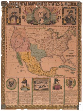

Object/Object