Map of the United States
PrinterPrinted by
Case,Tiffany & Co.
1836 - 1857
PublisherPublished by
Case,Tiffany & Co.
1836 - 1857
Date1851
MediumLithography; black printer's ink and watercolor on wove paper
DimensionsPrimary Dimensions (image height x width): 22 3/4 x 24 5/8in. (57.8 x 62.5cm)
Sheet (height x width): 23 3/4 x 25 5/8in. (60.3 x 65.1cm)
Sheet (height x width): 23 3/4 x 25 5/8in. (60.3 x 65.1cm)
ClassificationsGraphics
Credit LineConnecticut Museum of Culture and History collection
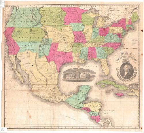
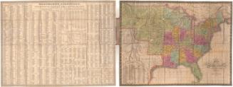
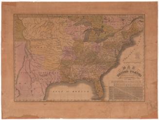
DescriptionMap of the United States, Mexico, Central America, Cuba, Jamaica and Haiti, from the border of Canada to the north, the Atlantic Ocean to the east, Panama to the south, and the Pacific Ocean to the west. The states and countries are colored green, blue, pink or yellow and are further defined by border lines. To the right of the map is an explanation of the symbols marking capital cities, "important" towns, large towns, smaller towns, missionary stations, court houses, forts, canals, military posts and mines. Elevation is depicted by the use of hachure marks. Two routes are marked, that from New York to Chagres, and that from Panama to San Francisco. The cartouche contains a portrait of George Washington below an eagle holding an olive branch, arrows and a seal featuring the flag of the United States. Below the portrait of Washington are two oak branches laden with acorns. In the Gulf of Mexico area of the map is a vignette of the United States Capitol.
Object number2012.312.154
MarkingsRecto, top and bottom left corners, printed in black ink on sticker: "MAPS / Drawer / 47"InscribedRecto, right side, printed in black ink: "MAP / of the / UNITED STATES / HARTD. / PUBLISHED BY CASE TIFFANY & COMPANY / 1851"NotesCartographic Note: Scale: 2 1/2 inches equals 300 milesCollections
- Maps and Charts: Finding Your Place in Connecticut History
On View
Not on view


Ithamar P. Berthrong
1908