Connecticut: Revolutionary War Period
DraftsmanDrawn by
Ed Vebell
American, born 1921
After a work byAfter a work by
Bernard Romans
American, 1741 - 1784
PublisherPublished by
Ellsworth S. Grant
American, 1917 - 2013
Date1976
MediumOffset print; black and colored printer's inks on paper, mounted on card stock
DimensionsPrimary Dimensions (image height x width): 22 1/4 x 28 1/8in. (56.5 x 71.4cm)
Sheet (height x width): 22 1/4 x 28 1/8in. (56.5 x 71.4cm)
Mount (height x width): 22 1/4 x 28 1/8in. (56.5 x 71.4cm)
Sheet (height x width): 22 1/4 x 28 1/8in. (56.5 x 71.4cm)
Mount (height x width): 22 1/4 x 28 1/8in. (56.5 x 71.4cm)
ClassificationsGraphics
Credit LineConnecticut Museum of Culture and History collection
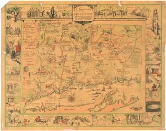
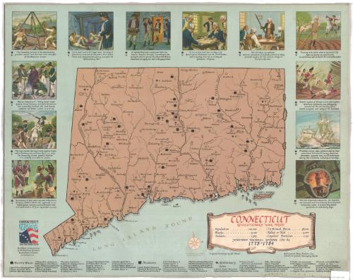
DescriptionMap of Connecticut during the Revolutionary War period, containing symbols and numbers that correspond to a list of symbols and numbers identifying historic houses, museums and Revolutionary War sites, as well as the twelve vignettes around the map. Vignettes depict the execution of Nathan Hale, General Wooster's death at the Battle of Danbury, Putnam's camp in Redding, Salisbury Iron Works, Newgate Prison, Benedict Arnold responding to the Lexington alarm, Washington and Rochambeau meeting in Wethersfield, Governor Jonathan Trumbull providing supplies for Washington's troops, Israel Putnam leaving the plow, the capture of Fort Griswold by the British, American privateers, and the first American submarine, the Turtle.
Object number2012.312.120
MarkingsVerso, stamped or printed onto card stock: "BAINBRIDGE / BOARD / TRADE NUMBER 80 MARK / 22X30 OR 30X40 / SINGLE OR DOUBLE / THICK / CHARLES T. BAINBRIDGE'S SONS, BROOKLYN, N.Y."InscribedRecto, bottom right, printed in red and black ink: "CONNECTICUT [printed in red ink] / REVOLUTIONARY WAR PERIOD [printed in red ink] / Population ... 200,000 In Armed Forces ... 38,000 / Blacks ... 5,100 Killed or Died ... 5,000 / Indians ... 1,365 Loyalist Families ... 2.250 / JONATHAN TRUMBULL, GOVERNOR 1769-84"Bottom right, printed in gray ink: "Based on a 1777 Map / by Bernard Romans"
Bottom right, printed in black ink: "Original Paintings by Ed Vebell"
Bottom right, printed in black ink: "A Project of Map Makers, Inc. / Ellsworth Grant, Managing Editor"
Bottom left, printed in black and colored ink: "CONNECTICUT / 1776 1967 / THE PROVISION STATE / An Official Commemorative / of the American Revolution / Bicentennial Commission / of Connecticut"
Verso, top, handwritten in pencil: "Deacidified / 5/14/02"NotesCartographic Note: No scale
Classification Note: In terms of this project, "historical maps" refer to those made at a later date than the time period depicted.
Subject Terms
- United States History Revolution, 1775-1783
- Connecticut
- Long Island Sound
- Hale, Nathan, 1755-1776
- Wooster, David, 1711-1777
- Putnam, Israel, 1718-1790
- Ordnance
- Arnold, Benedict 1741-1801
- Washington, George, 1732-1799
- Trumbull, Jonathan 1710-1785
- Ledyard, William, 1738-1781
- Submarines (Ships)
- Bushnell, David, 1740-1824
- Prints
- State Maps
- Historical Maps
- Map Cataloging Project
- Connecticut
Collections
- Maps and Charts: Finding Your Place in Connecticut History
On View
Not on view