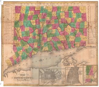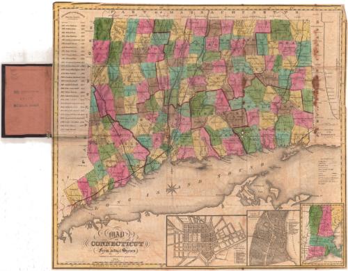
Map of Connecticut from actual Survey
PublisherPublished by
Brown and Parsons
American, 1838 - 1851
PrintmakerEngraved by
Daggett & Ely
American, 1831 - 1836
Date1848
MediumEngraving; black printer's ink and watercolor on wove paper, with cardboard covers
DimensionsPrimary Dimensions (image height x width): 19 1/8 x 21 1/2in. (48.6 x 54.6cm)
Sheet (height x width): 19 1/4 x 21 5/8in. (48.9 x 54.9cm)
Sheet (height x width): 19 1/4 x 21 5/8in. (48.9 x 54.9cm)
ClassificationsGraphics
Credit LineMuseum purchase
DescriptionPocket map of Connecticut, with Massachusetts to the north, Rhode Island to the east, the Long Island Sound to the south, and New York to the west. All of the towns in the state are bounded by solid black lines, and are colored blue, yellow, green, brown or pink, and the counties are bounded by broken solid and dotted lines that are colored dark pink. Turnpikes, "common" roads, places of public worship, courthouses, canals and railroads are depicted on the map with lines and symbols. The New York and New Haven, Housatonic, Hartford and Springfield and the Norwich and Worcester Railroads are marks in red. Four vignettes, one to the right of the map and three below it, show a "Profile of the Farmington Canal," plans of New Haven and Hartford, and the New England states, respectively. To the left of the map is a list of the governors of Connecticut since the charter.
Object number1983.194.0
MarkingsInside cover, center, stamped in blue ink: "THE CONNECTICUT / 83117 / HISTORICAL SOCIETY"InscribedFront cover, gold tooled: "MAP OF / CONNECTICUT"Inside cover, top left, handwritten in pencil: "MAPS / Shelf / 83117"
Recto, bottom left, printed in black ink: "MAP / OF / CONNECTICUT / From actual Survey / Published by BROWN & PARSONS, Hartford Conn. / 1848"
Bottom left, printed in black ink: "Engraved by Daggett & Ely New Haven."
NotesCartographic Note: Scale: 1 inch equals about 5 1/2 miles
Collections
- Maps and Charts: Finding Your Place in Connecticut History
On View
Not on view