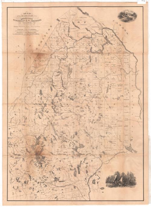
Map of the headwaters of the Aroostook, Penobscot and Saint Johns Rivers, Maine
MakerMade by
Thomas Sedgwick Steele
American, 1845 - 1903
Date1881
MediumLithography; black printer's ink on wove paper, backed with linen
DimensionsPrimary Dimensions (image height x width): 28 1/4 x 20in. (71.8 x 50.8cm)
Sheet (height x width): 21 7/16 x 29 1/2in. (54.5 x 74.9cm)
Mount (height x width): 21 7/16 x 29 1/2in. (54.5 x 74.9cm)
Sheet (height x width): 21 7/16 x 29 1/2in. (54.5 x 74.9cm)
Mount (height x width): 21 7/16 x 29 1/2in. (54.5 x 74.9cm)
ClassificationsGraphics
Credit LineConnecticut Museum of Culture and History collection
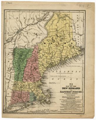
DescriptionMap of the part of Maine through which flow the headwaters of the Aroostook, Penobscot and St. John Rivers, from the borders of Canada (probably the province of Canada) to the north, New Brunswick to the east, the towns of Corinth and Hudson to the south, and Somserset County to the west. The rivers and area lakes are featured prominently on the map, with elevation being conveyed through hachure marks. The land is divided into towns and unnamed-but-numbered ranges, with unbroken boundary lines; and counties, with broken solid and dotted lines, and labeled in capital letters. There are two vignettes on the right side of the map. The one at the top depicts a canoe sitting on the bank of a river, paddle leaning against it. A camera is propped up on a tripon, facing a waterfall a short distance away. The one at the bottom shows a camping scene, with several men sitting around outside of tents, with various camping-related accoutrements around them.
Object number2012.312.72
MarkingsRecto, top right and left corners, printed in black ink on stickers: "MAPS / Box / 209"InscribedRecto, top left, printed in black ink: "MAP / of the HEADWATERS of the / AROOSTOOK, / PENOBSCOT & ST. JOHN RIVERS, / MAINE. / Prepared expressly for / THOMAS SEDGWICK STEELE, HARTFORD, CONN. / AUTHOR OF / CANOE AND CAMERA, / OR TWO HUNDRED MILES THROUGH THE MAIN FORESTS. / PADDLE AND PORTAGE / from MOOSEHEAD LAKE to the AROOSTOOK RIVER, MAINE &C. / COPYRIGHT 1881"Verso, top right, handwritten in pencil: "PRINT / DRAWER / 2A"
On the original envelope the map came in, printed in black ink: "THOMAS SEDGWICK STEELE'S / MAP of the CANOE TOURS of NORTHERN MAINE. / Price Post Paid $1.00 / Also Author of / CANOE AND CAMERA, or two hundred miles through the Maine Forests / PADDLE AND PORTAGE, or Moosehead Lake to [illegible] / Maine, Price, $1.50 / Address / [box for postage stamp, illegible]"NotesCartographic Note: No scale
Collections
- Maps and Charts: Finding Your Place in Connecticut History
On View
Not on view