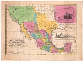
An Improved Map of the United States
DraftsmanDrawn by
Shelton & Kensett
American, founded 1813
PrintmakerEngraved by
Amos Doolittle
American, 1754 - 1832
PublisherPublished by
Shelton & Kensett
American, founded 1813
Date1813
MediumEngraving; black printer's ink and watercolor on laid paper
DimensionsPrimary Dimensions (image height x width): 17 5/8 x 19 1/2in. (44.8 x 49.5cm)
Platemark (height x width): 19 3/8 x 22in. (49.2 x 55.9cm)
Sheet (height x width): 20 1/8 x 24 5/8in. (51.1 x 62.5cm)
Platemark (height x width): 19 3/8 x 22in. (49.2 x 55.9cm)
Sheet (height x width): 20 1/8 x 24 5/8in. (51.1 x 62.5cm)
ClassificationsGraphics
Credit LineGift of Mrs. C. G. Rockwood
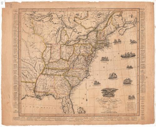
DescriptionMap of the United States, depicting East and West Florida, Georgia, South Carolina, North Carolina, Tennessee, Kentucky, Ohio, Virginia, Maryland, Pennsylvania, Delaware, New Jersey, New York, Connecticut, Rhode Island, Massachusetts, Vermont, New Hampshire, and the District of Maine. Orleans Territory, Mississippi Territory, Illinois Territory, Indiana Territory, Northwest Territory, and Louisiana are also shown, along with Upper and Lower Canada, Nova Scotia, and New Brunswick. Towns are marked with circles. Physical features include elevation, conveyed through clusters of peaks, rivers, islands, and lakes. In the Atlantic Ocean part of the map, several ships are depicted with descriptions of how they fared in battle in 1812 and 1813: the U.S. Frigate Chesapeak; the U.S. Frigate Constitution; the U.S. Sloop of War Wasp; the U.S. Sloop of War Hornet; the U.S. Sloop of War Argus; and the U.S. Frigate United States. Distance lists appear on both sides of the map, and below it are lists of the inhabitants and staple commodities of each state. The cartouche depicts an eagle with outstretched wings perched above the U.S. shield.
Object number1917.13.1
MarkingsRecto, top left corner, printed in black ink on sticker: "MAPS / Box / 199"InscribedRecto, top center, printed in black ink: "Copy right secured & entered according to act of Congress Novr. 8th 1813"Lower right, printed in black ink: "AN IMPROVED MAP / of the / United States / BY / Shelton & Kensett"
Bottom center, printed in black ink: "Published by Shelton & Kensett Cheshire Connect. Novr. 8th 1813"
Verso, top left corner, handwritten in pencil: "Print / Drw 2 / #9"
Bottom left corner, handwritten in red ink: "27379"NotesCartographic Note: Scale: about 1/2 inch equals 50 miles; 69 1/2 miles to 1 degree
Collections
- Maps and Charts: Finding Your Place in Connecticut History
On View
Not on view
George W. Corliss