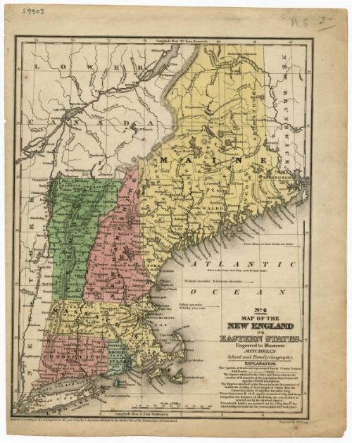
Map of the New England or Eastern States
PrintmakerEngraved by
James H. Young
American, active 1817 - 1866
PublisherPublished by
Samuel Augustus Mitchell
1792 - 1868
Date1839
MediumEngraving; black printer's ink on wove paper
DimensionsPrimary Dimensions (image height x width): 10 3/8 x 8 1/8in. (26.4 x 20.6cm)
Sheet (height x width): 11 5/8 x 9 1/4in. (29.5 x 23.5cm)
Sheet (height x width): 11 5/8 x 9 1/4in. (29.5 x 23.5cm)
ClassificationsGraphics
Credit LineMuseum purchase
DescriptionMap of New England, including "Lower Canada" (present-day Quebec), New Brunswick and New York. The New England states are colored pink, green or yellow, and each state is divided into counties, delineated with dotted lines. County towns and capitals are marked on the map. Railroads and canals are shown but are not labeled. Physical features depicted include elevation, conveyed through hachure marks, rivers, lakes, and islands.
Object number1952.99.0
MarkingsVerso, center, stamped in blue ink: "CtHi"InscribedRecto, top left, handwritten in black ink: "59903"Top right, handwritten in pencil: "N.E. 2-" ["2" is underlined]
Bottom, printed in black ink: "No. 6 / MAP OF THE / NEW ENGLAND / OR / EASTERN STATES. / Engraved to Illustrate / MITCHELL'S / School and Family Geography. / EXPLANATION."
Bottom left corner, printed in black ink: "Entered according to Act of Congress, in the year 1839, by S. Augustus Mitchell, in the Clerk's Office of the District Court of Connecticut."
Bottom right corner, printed in black ink: "Engraved by J.H. Young"
Verso, top, handwritten in pencil: "Map Box #101"
Center, handwritten in pencil: "59903"
Bottom left, handwritten in pencil: "Map Box / 101"
Bottom right, handwritten in pencil: "59903"
NotesCartographic Note: Scale: 1 inch equals almost 50 miles
Collections
- Maps and Charts: Finding Your Place in Connecticut History
On View
Not on view