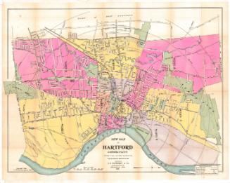
New Map of Hartford from the Latest Surveys
PrintmakerLithographed by
Kellogg & Bulkeley
American, 1867 - 1990
PublisherPublished by
Elihu Geer
American, 1817 - 1887
Date1877
MediumLithography; black printer's ink and watercolor on wove paper, in cardboard covers
DimensionsPrimary Dimensions (Map of Hartford image height x width): 10 x 18 3/4in. (25.4 x 47.6cm)
Sheet (Map of Hartford height x width): 10 1/2 x 19in. (26.7 x 48.3cm)
Sheet (Map of Hartford height x width): 10 1/2 x 19in. (26.7 x 48.3cm)
ClassificationsGraphics
Credit LineMuseum purchase
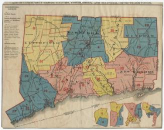
DescriptionTwo maps within one set of covers. The main map is a pocket map of Connecticut and the other map, described here, is a pocket map of Hartford, with Bloomfield to the north, East Hartford to the east, Wethersfield to the south, and West Hartford to the west. The city is divided into wards, colored pink, blue or yellow, and each contains a number that represents the location of that ward's voting place. Green is used to depict parks and cemeteries. The Hartford and New Haven; Hartford, Providence and Fishkill; Connecticut Western; and Connecticut Valley Railroad lines run through town. There are concentric circles in one-half mile increments from Union Station.
Object number1976.131.4b
InscribedFront cover, gold tooled: "CONNECTICUT"Inside front cover, top left, handwritten in pencil: "77075"
Recto, top right, printed in black ink: "JULY 1877 / ELIHU GEER'S / NEW / MAP OF HARTFORD, / FROM THE LATEST SURVEYS."
Bottom, printed in black ink: "Entered according to act of Congress in the year 1874 by Elihu Geer in the office of the Librarian of Congress at Washington D.C."
Verso, bottom right, in pencil, "1976.131.4b"
NotesCartographic Note: Scale: 1 inch equals 1500 feet
Collections
- Maps and Charts: Finding Your Place in Connecticut History
On View
Not on view


Kellogg & Bulkeley
1910-1915
Kellogg & Bulkeley
1915-1920