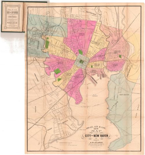
Price, Lee & Co.'s New Map of the City of New Haven
SurveyorSurveyed by
Silus W. Searle
American, 1822 - 1902
DraftsmanDrawn by
Silus W. Searle
American, 1822 - 1902
PublisherPublished by
Price & Lee Co.
American
Dateafter 1873
MediumLithography; black printer's ink and watercolor on wove paper, in cardboard covers
DimensionsPrimary Dimensions (image height x width): 28 x 21 7/8in. (71.1 x 55.6cm)
Sheet (height x width): 29 3/8 x 22 7/8in. (74.6 x 58.1cm)
Sheet (height x width): 29 3/8 x 22 7/8in. (74.6 x 58.1cm)
ClassificationsGraphics
Credit LineMuseum purchase
DescriptionPocket map of the city of New Haven, Connecticut, with Whitneyville to the north, East Haven to the east, the harbor to the south, and Allington to the west. The city is divided into wards, each colored pink, yellow, blue or peach. Westville and Raynham are colored blue, and Fair Haven East is colored yellow. Parks and cemeteries are colored green. City streets are shown and labeled, along with some buildings, including Yale, City Hall, and two hospitals. Steam railroad lines shown include the New York, New Haven and Hartford; New Haven and Derby; New Haven and Northampton; Shore Line; and the New York and Boston Air Line. Horse railroads ran along Kimberly Avenue, Howard and Sylvan Avenues, Chapel Street, Grand Street, Shelton Avenue (New Haven and Centerville Horse Railroad), Whitney Avenue (New Haven and Whitneyville Horse Railroad) and Meadow Street. There are concentric circles from city hall in one-mile increments.
Object number1977.121.1
InscribedFront cover, gold tooled: "Map of / THE CITY OF / NEW HAVEN"Inside front cover, top left, handwritten in pencil: "MAPS / Shelf / 78055"
Top, handwritten in pencil: "1870's"
Top, printed in black ink: "ESTABLISHED 1873. / PRICE, LEE & CO., BOOK and JOB PRINTERS / AND PUBLISHERS OF / DIRECTORIES"
Recto, bottom, printed in black ink: "PRICE, LEE & CO'S. / NEW / MAP / OF THE / CITY OF NEW HAVEN / SURVEYED BY S.W. SEARLE / Surveyor and Civil Engineer / and drawn by him expressly for / their new City Directory. / Scale 1200 Feet to the inch"NotesCartographic Note: Scale: 1 inch equals 1200 feet
Collections
- Maps and Charts: Finding Your Place in Connecticut History
On View
Not on view