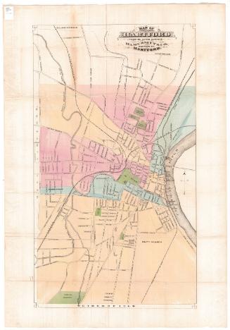
Elihu Geer's New Map of Hartford from the latest surveys
PublisherPublished by
Elihu Geer
American, 1817 - 1887
PrinterPrinted by
Elihu Geer
American, 1817 - 1887
Date1882
MediumLithography; black printer's ink and watercolor on wove paper, in cardboard covers
DimensionsPrimary Dimensions (image height x width): 18 3/8 x 10in. (46.7 x 25.4cm)
Sheet (height x width): 20 x 12 1/4in. (50.8 x 31.1cm)
Sheet (height x width): 20 x 12 1/4in. (50.8 x 31.1cm)
ClassificationsGraphics
Credit LineConnecticut Museum of Culture and History collection
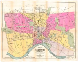
DescriptionMap of part of Hartford, Connecticut, from the town line of Bloomfield to the north, the Connecticut River to the east, the town line of Wethersfield to the south, and the town line of West Hartford to the west. The city is divided into eight wards, colored blue, pink or yellow, with the locations of each ward's voting place denoted with the number of the ward.
Bushnell Park and four cemeteries are colored green. There are concentric circles at 1/2 mile intervals from Union Station. The roads are labeled. The Hartford and New Haven; Hartford, Providence and Fishkill; Connecticut Western; and Connecticut Valley Railroads run through town. Physical features include the Connecticut and Park Rivers, and Meadow Creek. A pamphlet accompanying the map contains information about the streets of Hartford, including their location on the map and whether they had sewage and gas infrastructure and whether they were paved or curbed.
Bushnell Park and four cemeteries are colored green. There are concentric circles at 1/2 mile intervals from Union Station. The roads are labeled. The Hartford and New Haven; Hartford, Providence and Fishkill; Connecticut Western; and Connecticut Valley Railroads run through town. Physical features include the Connecticut and Park Rivers, and Meadow Creek. A pamphlet accompanying the map contains information about the streets of Hartford, including their location on the map and whether they had sewage and gas infrastructure and whether they were paved or curbed.
Object number1989.172.0
MarkingsRecto, center, stamped in blue ink: "CtHi"InscribedFront cover, gold tooled: "GEER'S MAP / AND / STREET GUIDE / OF / HARTFORD. / 1882"Inside cover, top left, handwritten in pencil: "Maps / 89471"
Recto, title page of pamphlet, printed in black ink: "ELIHU GEER'S / NEW MAP / AND GUIDE TO THE / LOCATIONS AND NUMBERS / OF / STREETS AND AVENUES / IN THE / CITY OF HARTFORD; / TO WHICH IS ADDED THE / WARD LOCATION OF EACH STREET; / ALSO, LETTER INDICES TO STREETS HAVING / WATER PIPES, GAS PIPES AND SEWERS; / ALSO, THE STREETS THAT HAVE BEEN / MACADAMIZED, CURBED, ETC. / HARTFORD: / ELIHU GEER, PUBLISHER AND PRINTER, 16 STATE ST. / 1882."
Verso, title page, printed in black ink: "ENTERED according to Act of Congress in the year 1874, by / ELIHU GEER, / in the office of the Librarian of Congress, at / Washington, D.C."
Recto, top right, printed in black ink: "JULY / 1881 / ELIHU GEER'S / NEW / MAP OF HARTFORD, / FROM THE LATEST SURVEYS / SCALE 1500 FEET TO AN INCH. / 1, 2, 3, 4, 5, 6, 7 indicate the several Ward voting places. / The circles drawn here are each 1/2 mile apart, having the Union Railroad Depot as their center"
Bottom, printed in black ink: "Entered according to act of Congress in the year 1874 by Elihu Geer in the office of the Librarian of Congress in Washington D.C."
Verso, center, handwritten in pencil: "89471"NotesCartographic Note: Scale: 1 inch equals 1500 feet
Collections
- Maps and Charts: Finding Your Place in Connecticut History
On View
Not on view


Kellogg & Bulkeley
1910-1915