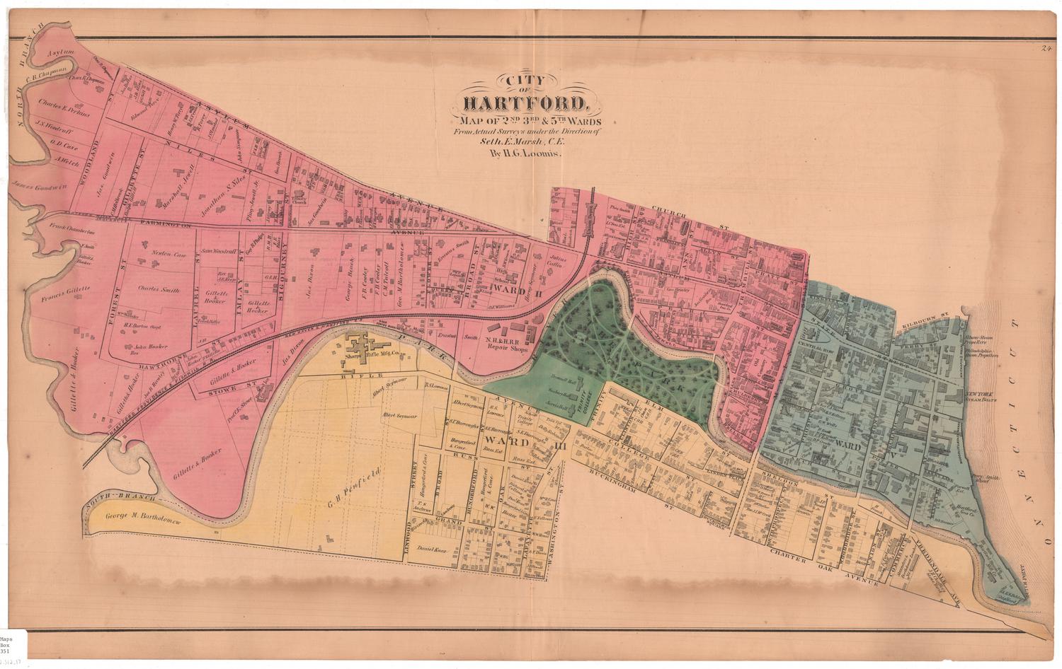
City of Hartford, Map of 2nd, 3rd & 5th Wards
SurveyorSurveyed by
Hiram G. Loomis
American, 1834 - 1911
SurveyorSurveyed by
Seth E. Marsh
American, about 1823 - 1878
PrinterEngraved by
Kellogg & Bulkeley
American, 1867 - 1990
PrinterPrinted by
Kellogg & Bulkeley
American, 1867 - 1990
MakerColored by
Kellogg & Bulkeley
American, 1867 - 1990
PublisherPublished by
Baker & Tilden
founded 1869
Date1869?
MediumLithography; black printer's ink and watercolor on wove paper
DimensionsPrimary Dimensions (image height x width): 16 5/8 x 28 1/8in. (42.2 x 71.4cm)
Sheet (height x width): 17 5/8 x 28 1/8in. (44.8 x 71.4cm)
Sheet (height x width): 17 5/8 x 28 1/8in. (44.8 x 71.4cm)
ClassificationsGraphics
Credit LineConnecticut Museum of Culture and History collection
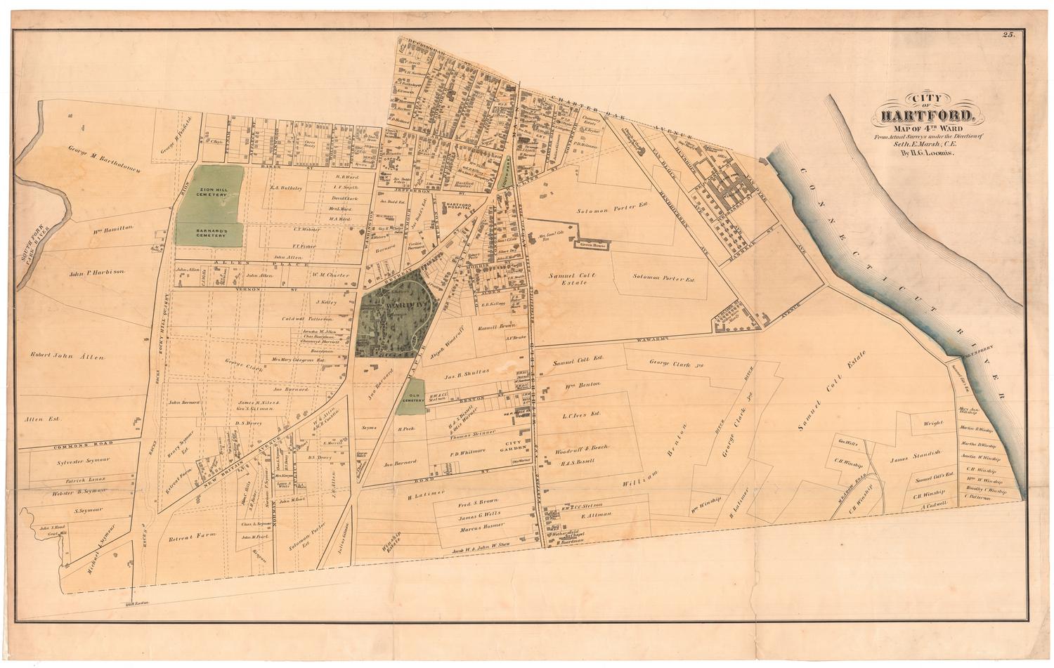
DescriptionStreet map of Hartford, Connecticut's 2nd, 3rd and 5th Wards. Ward 2 is bounded to the north by Asylum Avenue and Church Street, to the east by Main Street, to the south by the Park River, and to the west by the North Branch of the Park River. The Hartford, Providence & Fishkill and New Haven and Hartford Rail Roads run through it, with Union Station appearing south of Church Street. Ward 3 is bounded by the Park River to the north, Vredendale Avenue to the east, Buckingham Street and Charter Oak Avenue to the south, and the South Branch of the Park River to the west. Bushnell Park (referred to as "The Park") and Trinity College are in between Wards 2 and 3. War 5 is bounded to the north by Kilbourn Street, the Connecticut River to the east, the Park River to the south, and Main Street to the west. Residences and commercial establishments are included and sometimes, but not always, labeled with the name of the owner.
Object number2012.312.17
InscribedRecto, top center, printed in black ink: "CITY OF HARTFORD, / MAP OF 2ND 3RD & 5TH WARDS / From Actual Surveys under the Direction of / Seth. E. Marsh, C.E. / By H.G. Loomis."Verso, printed in black ink: a list of "BUSINESS ADVERTISING REFERENCES FOR HARTFORD," with several "W" entries and "Miscellaneous" on the left page, and M-V on the the right.
Names of the property owners on the map include:
On Woodland Street (near North Branch):
James Goodwin, A. Welch, O. D. Case, J. S. Woodruff, Charles E. Perkins, Charles R. Chapman (occurs twice)
On Asylum Avenue:
James Bolter, J. B. Stone, G. G. Sill, Edmund Terrv, Henry W. Terry, J. S. Tryon, R. Terry, J. Olmsted, John Simpson, George Bench, G. B. Barnes, J. B. Burr, N. G. B., E. B. R., N. B. S., W. C. H., M. Howard, T. M. Day, Harvey Seymour, Julius Catlin, Dr. S. B. Beresford, Miss L. Goodrich, S. Coit, H. Coming (near the Union Station Depot), Smith Bourn and Co., J. G. Batterson, Mrs. T. C. Brownell
On Gillette Street:
James Goodwin, C. M. Holbrook
On Niles Street:
Marshall Jewell, Jonanthan S. Niles, Pliny Jewell Jr., J. S. Gray, H. J. Johnson and H. L. Welch
On Farmington Avenue:
Mrs. Watkinson (in front of the Trinity Church), James Goodwin, N. G. Hinkley, T. Sisson, C. F. Howard, H. K. Morgan, S. E. Elmore, G. W. Williams, H. C., A. K., James Dixon, George Beach, F. B. Cooley, F. B. Cooley, C. M. Talcott, George M Bartholomew, P. S. Vinton, T. T. Fisher, Erastus Smith
On Forest Street:
Frank Chamberlain, F. Smith, Gillett and Hooker, Francis Gillette, Gillette and Hooker
On Laurel Street:
Newton Case, Charles Smith, William Wander, H. E. Burton Occpt., Res John Hooker
On Imlay Street:
Sam Woodruff, Rev. J. R. Keep, Gillette and Hooker, Frank Bolles, J. H.
On Sigournery Street:
Gillett and Hooker, Guy R. Phelps, R. M. B., F. E. Bliss
On Broad Street:
F. P. Lepard, M. Lord, E. Goodman, R. Blodgett, N. Peckhom, B. W. Green, O. E. Williams
On Hawthorne Street:
Gillette and Hooker, Jos. R. Hawley, C. Sockrel, John Hooker, F. Gillette
On Stowe Street:
Gillette and Hooker, Prof. C. E. Stowe, James Dixon
On South Brank:
George Bartholomew, G H. Penfield,
On Rifle Avenue:
Albert Seymour (occurs twice), R. S. Lawrence (occurs twice)
On Broad Street (Ward III):
Hangerford and Cone, T. S. Andrews
On Grand Street:
H. Griswold, Daniel Knox, W. H. G., S. Andrews
On Hungerford Street:
Hungerford and Cone, S. L. Burroughs
On Oak Street:
W. W., Hungerford and Cone, S. E. Burroughs (occurs twice)
On Lafayette Street:
Will Green, Rev George Clark, J. B. Powell, G. F. Davis, W. W. House, F. Fellowes, William R. Cone, Mrs. H. Barnard
On Buckingham Street:
R. S. D., O. H. E., C. H. Baranard, C. T. W.
On College Street:
C. H. B. (Reoccurring many times on Elm street, Clinton and West Street)
On Sheldon Street:
J. P. Forster Jr., National Screw Co., H. French, B. W. and H. Coal Yard
On South Prospect Street:
Rev. J. J. McCook, A. W. Butler, H. C. Robinson, R. Brown, D. Mayer, D. Stevens
On Commerce Street:
Planning and Mill and Lumber Yard, E. Taylor and Co., Saunders and Bartholomew Lumber Yard
On Vredendale Avenue:
J. H. Chaffee's Stone Yard
Near the Dutch Point and along the Wharf:
S. and E. S. Beldens Ship Yard, Hartford Steam Saw Mill Co., Hartford Gas Co., Mr. Brazier, Farwell Est., M. W. Chapin
On Commerce Street (Ward V):
Hatch and Tyler, Woodruff and Beach Foundry (?), W & B Office (?), Woodruff's Beach
On Prospect Street (Ward V):
George H. Clark, D. P. Crosby, N. J. Brockett and E. N. Kellogg, R. Buell, E. W. Wells, E. N. Kellogg, Rev. C. A. Skinner Occpt., C. W. Everest, J. C. Parsons, G. M. Bartholomew Res, Austin Dunham, J. C. Parsons
On State Street:
Pitkin Bros and Co.
On Pearl Street:
George Brinley
On Hicks Street:
P. Jewell and Sons
On Allyn Street:
W. and Beach, T. M. Allyn,
On Church Street:
Thomas Smith, H. C. Deming,
On High Street (Ward II):
J. H. Goodwin, J. C. Batterson Mrs. Goodwin, H. C. Judd, T. IvesNotesCartographic Note: No scale
Subject Note: The map was originally published in 1869 by Baker & Tilden in the Atlas of Hartford City and County, with a Map of Connecticut From Actual Surveys.
Collections
- Maps and Charts: Finding Your Place in Connecticut History
On View
Not on view