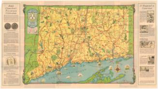
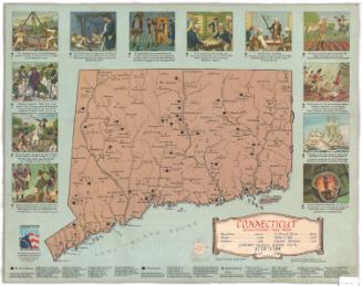
Map of Connecticut, Issued in Commemoration of the State's Tercentenary
DraftsmanDrawn by
John Held Jr.
American, 1889 - 1958
PublisherPublished by the
Aetna Casualty and Surety Company
American, founded 1917
Date1935
MediumOffset lithography; black and colored printer's inks on wove paper
DimensionsPrimary Dimensions (image height x width): 17 1/4 x 23in. (43.8 x 58.4cm)
Sheet (height x width): 18 x 31 7/8in. (45.7 x 81cm)
Sheet (height x width): 18 x 31 7/8in. (45.7 x 81cm)
ClassificationsGraphics
Credit LineGift of Mrs. John A. Campbell
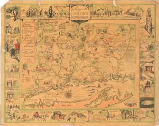
DescriptionFolding map of the state of Connecticut, with the Long Island Sound to the south and New York to the west. The map marks the state's major highways and uses pictures to show the locations of historic sites, including battles and notable homes and schools. Text on both sides of the image describes the significance of the pictures. On the verso are photographs and text about some of Connecticut's landmarks, a memo from the governor, and sketches of the seventeen original towns.
Object number1983.195.1
InscribedRecto, top left, printed in black and colored inks: "MAP / of / Connecticut / Issued in / COMMEMORATION / of the State's / Tercentenary / 1635 1935 / Showing Principal / HIGHWAYS / AND HISTORICAL / REFERENCES / CONTRIBUTED BY / THE AETNA CASUALTY & SURETY COMPANY"Bottom right, printed in black ink: "Cartography by / John Held Jr"
Bottom right, printed in black ink: "COPYRIGHT BY / THE AETNA CASUALTY & SURETY COMPANY / HARTFORD, CONNECTICUT"
Verso, bottom left, handwritten in pencil: "83432"
Bottom left, printed in black and colored inks: "Map of / Connecticut / Showing Principal HIGHWAYS / With illustrations by / JOHN HELD Jr. / and Historic / references / Issued in / Commemoration / of the State's / Tercentenary / 1635 | 1935 / COPYRIGHT 1935 BY AETNA CASUALTY AND SURETY COMPANY"
NotesCartographic Note: No scale
Subject Terms
- Connecticut
- Highways
- Tapping Reeve House and Law School (Litchfield, Conn.)
- United States History Revolution, 1775-1783
- Mills and mill-work
- Charter Oak (Hartford, Conn.)
- Webb house, Wethersfield, Conn.
- Henry Whitfield State Museum (Conn.)
- Newgate Prison (East Granby, Conn.)
- Glebe House Museum (Woodbury, Conn.)
- Nathan Hale Schoolhouse (New London, Conn.)
- Old State House (Hartford, Conn.)
- Branford (Conn.)
- Fairfield (Conn.)
- Farmington (Conn.)
- Guilford (Conn.)
- Middletown (Conn.)
- Milford (Conn.)
- New Haven (Conn.)
- Hartford (Conn.)
- New London (Conn.)
- Norwalk (Conn.)
- Norwich (Conn.)
- Old Saybrook (Conn.)
- Stamford (Conn.)
- Stonington (Conn.)
- Stratford (Conn.)
- Wethersfield (Conn.)
- Windsor (Conn.)
- Lithographs
- State Maps
- Pictorial Maps
- Road Maps
- Map Cataloging Project
- Connecticut
Collections
- Maps and Charts: Finding Your Place in Connecticut History
On View
Not on view