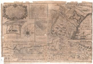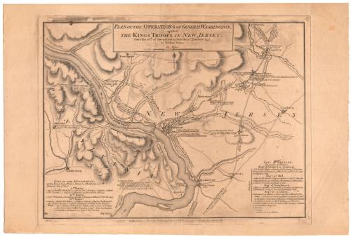
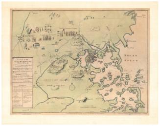
Plan of the Operations of General Washington against the Kings Troops in New Jersey from the 26th of December 1776 to the 3rd of January 1777
PublisherPublished by
William Faden
British, 1750 - 1836
Date1777
MediumEngraving; black printer's ink on wove paper
DimensionsPrimary Dimensions (image height x width): 11 3/8 x 15 3/16in. (28.9 x 38.6cm)
Platemark (height x width): 12 1/8 x 15 7/8in. (30.8 x 40.3cm)
Sheet (height x width): 13 3/8 x 20in. (34 x 50.8cm)
Platemark (height x width): 12 1/8 x 15 7/8in. (30.8 x 40.3cm)
Sheet (height x width): 13 3/8 x 20in. (34 x 50.8cm)
ClassificationsGraphics
Credit LineConnecticut Museum of Culture and History collection
DescriptionMap of Pennsylvania and New Jersey tracing the Battles of Trenton and Princeton, fought by the Continental Army under the command of General George Washington against the British. It extends from Kingstown to the northeast, Cranberry to the east, Bristol to the south, and Newtown to the west. The Delaware River runs south from the top left corner to the bottom left. Double parallel lines show the army's routes, with rectangles marking camps and posts along the way. Symbols for what may be town halls mark the locations of towns and settlements, and closed rectangles are used to denote the presence of dwellings. Elevation is depicted through hachure marks. Inscriptions on the map explain the notable events in the battles. In the lower left corner of the map is a list of lives lost in the Battle of Princeton, fought on January 3, 1777; in the lower right corner is a list of lives lost in the Battle of Trenton, fought on December 26, 1776.
Object number2012.312.213
MarkingsVerso, center, stamped in blue ink: "CtHi"InscribedRecto, top, printed in black ink: "PLAN OF THE OPERATIONS OF GENERAL WASHINGTON, / against / THE KINGS TROOPS IN NEW JERSEY. / from the 26th. of December 1776 to the 3d. January 1777. / by William Faden"Bottom, printed in black ink: "London, Published according to Acts of Parliament 15th April 1777. by Wm. Faden, Corner of St. Martins Lane, Charing Cross."
Bottom left, handwritten in pencil: "15"
Verso, top left, handwritten in pencil: "MAP / Box / 22"
Bottom left, handwritten in pencil: "MAP BOX / 22"NotesCartographic Note: Scale: Almost 3 3/8 equals 6 miles
Collections
- Maps and Charts: Finding Your Place in Connecticut History
On View
Not on view
George W. Corliss