Borough of Willimantic in the Town of Windham
SurveyorSurveyed by
Ormando Willis Gray
American, born 1829
PrinterPrinted by
Kellogg & Bulkeley
American, 1867 - 1990
PrinterLetterpress by
Case, Lockwood and Brainard Company
American
PublisherPublished by
C. G. Keeney
American, about 1810 - 1888
Date1869
MediumLithography; black printer's ink and watercolor on wove paper
DimensionsPrimary Dimensions (image height x width): 16 1/8 x 27in. (41 x 68.6cm)
Sheet (height x width): 18 1/8 x 28 1/2in. (46 x 72.4cm)
Sheet (height x width): 18 1/8 x 28 1/2in. (46 x 72.4cm)
ClassificationsGraphics
Credit LineConnecticut Museum of Culture and History collection
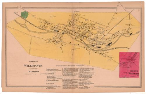
DescriptionMap of Willimantic, Connecticut, with Prospect Street to the north, Oak Street to the east, Pleasant Street to the south, and the cemetery to the west. The Willimantic River runs through the borough, with cotton and linen mills lining its banks. The Providence, Hartford and Fishkill; New London Northern; and Boston, Hartford and Erie Railroad lines also run through Willimantic. Private residences, businesses and public buildings are marked with black rectangles and are labeled with the owner or occupant's name. There is an inset map of North Windham in the bottom right corner of the sheet, which shows residences and a woolen factory, marked with black rectangles and labeled with the owner or occupant's name. Below the map is the Willimantic Business Directory, which lists the agents, carpenters, druggists, hotels, lawyers, manufacturers, merchants and dealers, meat markets, physicians and dentists, and jewelers.
Object number2006.118.0
MarkingsRecto, bottom left corner, printed in black ink on sticker: "Maps / Box / 326 / (99356)"Verso, bottom right corner, stamped in blue ink: "THE CONNECTICUT / HISTORICAL SOCIETY"InscribedRecto, left, printed in black ink: "BOROUGH / OF / WILLIMANTIC / IN THE TOWN OF / WINDHAM"
Right, printed in black ink: "NORTH / WINDHAM"NotesCartographic Note: Scale: 1 inch equals 25 rods
Constituent Note: There is no imprint information on the map itself. Information regarding the surveyor, printers, and publisher of this map comes from the title page of the Atlas of Windham and Tolland Counties in which this map originally appeared.
Collections
- Maps and Charts: Finding Your Place in Connecticut History
On View
Not on view