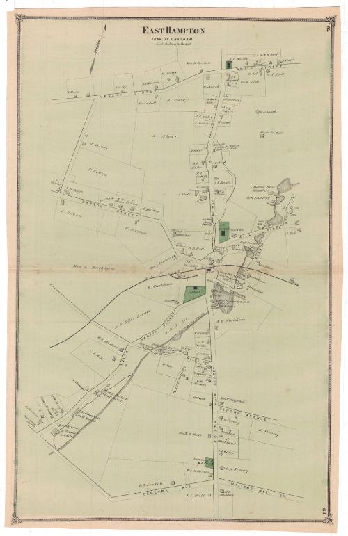
East Hampton. Town of Chatham
PublisherPublished by
F. W. Beers & Co.
American
Date1874
MediumLithography; black printer's ink and watercolor on wove paper
DimensionsPrimary Dimensions (image height x width): 22 3/8 x 14 1/4in. (56.8 x 36.2cm)
Sheet (height x width): 23 x 14 3/4in. (58.4 x 37.5cm)
Sheet (height x width): 23 x 14 3/4in. (58.4 x 37.5cm)
ClassificationsGraphics
Credit LineMuseum purchase
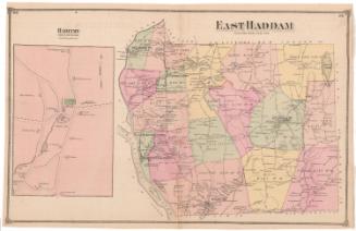
DescriptionMap of East Hampton, Connecticut, in the town of Chatham, depicting the local roads and land lots. The lots are divided with thin solid lines and are labeled with the owner or occupant's name. Buildings are depicted with shaded rectangles. A school, a Methodist Episcopal Church, First Congregational Church and Congregational Church are all colored green. The Air Line Railroad runs through the town, as does the Pocotopaug Creek, with various mills, factories and foundries situated long it.
Object number1980.100.19
MarkingsRecto, top left corner, printed in black ink on sticker: "Maps / Box / 353"Right side, stamped in blue ink: "THE CONNECTICUT / 80916 / HISTORICAL SOCIETY"InscribedRecto, top, printed in black ink: "EAST HAMPTON / TOWN OF CHATHAM"
Top right corner, printed in black ink: "62"
Bottom right corner, printed in black ink: "63"
Streets include Veazey Street, Smith Street, North Street, Barton Street, Mill Street, Bevin Avenue, Abell Avenue, South Barton Street, Niles Avenue, Strong Avenue, South Main Street, Miller’s Hill Street, Genevra Avenue, Air Line Railroad.
Natural landmarks include: Pocotopaug Creek.
Property owners north of Air Line Railroad include: J. Ahern, Z. Cody, E.D. Barton, H. Veazey, D. Barton, N.C. Smith, C.A. and W.H. Buell, J.N. Goff, W.G. Buell, J.C. Shepard, E.G. Cone, H.G. Clark, S.S. Hall, J. Drury, John M. Ackley, J. Griffith, W.E. Ackley, F. Ackley, H.H. Abbe, H.S. Smith, Bevin Brothers, H. Snow, A. Abell, A.B. White, H.E. Rich, A. Clark, I.A. Bevin, F.E. Adams, H.E. Rich, S.B. Childs, P. Bevin, R.S. Clark, C. Bevin, H. Barton, E.C. Barton, L. Markham, J.J. Niles, B.B. Hall, L. Hall, O.C. West, D.B. Niles, A.G. Bevin, P. Bevin.
Property owners south of Air Line Railroad include: S. Skinner, Henry Skinner, John Stars, C.L. Hill, W.E. Barton, D.B. Niles, E. Markham, M. Wall, D.W. Watrous, Adams and Markham, Goff and Abell, A.H. Markham, W.B. Young, J.W. Smith, A.N. Niles, R. Day, Dr. W.F.C. Notling, J. Kellogg, J.H. Worthington, W.H. Nichols, O. Clark, Mrs. M. Edgerton, H. Strong, S.A. Markham, G. Buckland, I.D. Willey, Mrs. M.B. Hall, Mrs. L. Sexton, D.W. Sexton, L.L. Hall, H.D. Chapman.
Noteworthy buildings include: Congregational Church, hotel, H.E. Rich Store and Masonic Hall, school, Methodist Episcopal Church, Pierce and Buckland Store, C.O. Sears and Co. Store and Post Office, Bevin Brothers Manufacturing Company, bell foundry, saw mill, Gong Bell Manufacturing Company, East Hampton Bell Company, Coffin Trimming and Bell Manufacturing, Paper Box Shop, Tin Shop.
NotesCartographic Note: Scale: 1 inch equals 20 rods
Collections
- Maps and Charts: Finding Your Place in Connecticut History
On View
Not on view