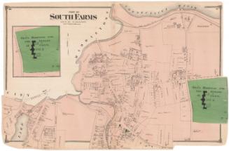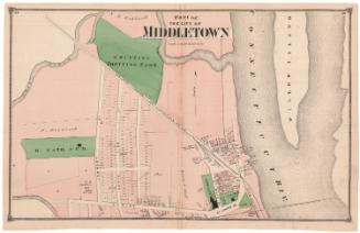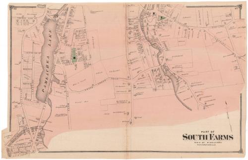
Part of South Farms, Town of Middletown
PublisherPublished by
F. W. Beers & Co.
American
Date1874
MediumLithography; black printer's ink and watercolor on wove paper
DimensionsPrimary Dimensions (image height x width): 14 5/8 x 23 1/8in. (37.1 x 58.7cm)
Sheet (height x width): 15 x 23 3/8in. (38.1 x 59.4cm)
Sheet (height x width): 15 x 23 3/8in. (38.1 x 59.4cm)
ClassificationsGraphics
Credit LineMuseum purchase
DescriptionMap of South Farms in Middletown, Connecticut, depicting roads and land lots, labeled with the owner's name. Buildings are indicated with squares. Two schools and an Episcopalian church are colored green. Natural features include Pameachea Lake, Glen Lake, West Lake, and Sanseer Creek.
Object number1980.100.7
MarkingsRecto, bottom left corner, printed in black ink on sticker: "Maps / box / 333"Verso, bottom right corner, stamped in blue ink: "THE CONNECTICUT / 80916 / HISTORICAL SOCIETY"InscribedRecto, top left corner, printed in black ink: "44"
Top right corner, printed in black ink: "45"
Bottom right, printed in black ink: "PART OF / SOUTH FARMS / TOWN OF MIDDLETOWN"NotesCartographic Note: Scale: 1 inch equals 20 rods
Collections
- Maps and Charts: Finding Your Place in Connecticut History
On View
Not on view