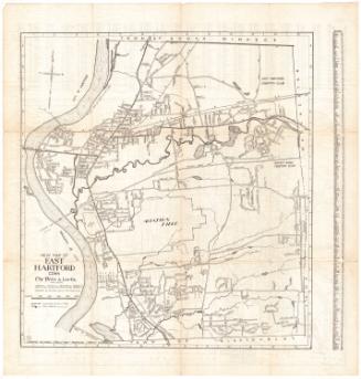
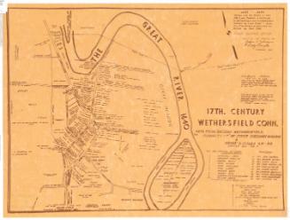
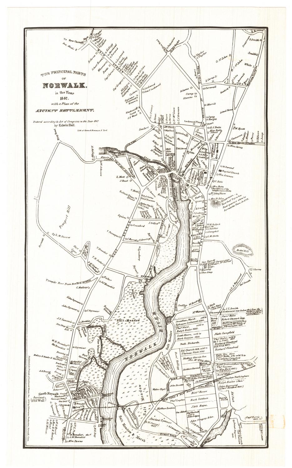
Map of Windsor, 1633-1650
PublisherPublished by
Connecticut Museum of Culture and History
American, founded 1825
Date1893
MediumOffset lithography; black printer's ink on wove paper
DimensionsPrimary Dimensions (image height x width): 8 1/2 x 6 3/8in. (21.6 x 16.2cm)
Sheet (height x width): 18 x 14 1/4in. (45.7 x 36.2cm)
Sheet (height x width): 18 x 14 1/4in. (45.7 x 36.2cm)
ClassificationsGraphics
Credit LineConnecticut Museum of Culture and History collection
DescriptionMap of Windsor in the center of a sheet of text titled, "Places of Historic Interest in Windsor, Connecticut." The map depicts residential lots with squares representing houses and labeled with the owner's or occupant's name, as they appeared between 1633 and 1650. The settlement extends from the Farmington River to the north, the Connecticut River (called the Great River on the map) to the east, and residences to the south and west. Physical features include Hoyte's Meadow, Mr. Phelps Meadow, North West Field, Rocky Hill and the Great Meadow. Elevation is conveyed with hachure marks.
Object number2012.312.33
MarkingsRecto, center, stamped in blue ink: "CtHi"InscribedRecto, top left, printed in black ink: "PLACES OF HISTORIC INTEREST IN / WINDSOR, CONN."Center, printed in black ink: "THE HOUSE LOTS EXTENDED TO THE FOOT OF THE MEADOW HILL. / THE ALLOTMENTS OF MEADOW LAND GENERALLY OF THE SAME WIDTH / AND EXTENDING TO THE RIVER."
Center, printed in black ink: "THIS PORTION OF THE MEADOW WAS / ALLOTTED TO SETTLERS LIVING IN THE / PALISADO ON BACKER ROW AND / SOUTH AND WEST OF THE RIVULET."
Center, printed in black ink: "MAP OF / WINDSOR / 1633-1650."
Handwritten in pink ink at the top of the map: "Levi Hayden House / 1737 / Site of Picketts Tavern / 1780 / Pear Tree / about 1720 / Capt. Nathl Hayden / 1776"
Route in pink ink drawn on top of some of the streets
Center of map, handwritten in pink ink: "Broad St Park"
Bottom of map, handwritten in pink ink: "Stony Hill"
Verso, center, printed in black ink: "CONNECTICUT HISTORICAL SOCIETY / FIELD DAY, JUNE 14, 1893 / WINDSOR"
Map Transcription
Names of the property owners indicated on the map include:
Near the Indian Neck:
Bartley, Holeomb (?), Griswold
Near Hoyte's Meadow:
Hoyte
Near Mr. Phelp's Meadow:
Phelps, William Phelps Jr., Orton
Along the Rivulet (now Farmington River) and around Mill Brook:
Tillev, Weller, Collini, Bascomb, Thrall, Palmer, Hillier, Buell, Pond, Hydes, Barber, A. Alford, J. Gillett, Hannah Newberry, Rebecca Newberry, Mary Newberry, Sarah Newberry, John Newberry, Benjamin Newberry, Joseph Newberry, N. Cooke, Howard, Rev. John Warham, Arthur Williams, Birge, B. Alford, John Drake Jr., John Drake, D. Clarke, Rawlins
Around the Little Meadow and along the Backer Row:
Foulkes, Owen, Filer (?), Parkman, Egglestone, Stuckey, Young, Thornton, Sension, Staires, Gibbs
Along the Great River and near the Great Meadow:
Palisado, Dewes, Cooke, Pomroy, Hosford, Denslow, Baker, Ford, Terry, George Hull, Buckland, W. M. Rockwell, J. Clarke, Winchell Dible, Carter, Hannum Tilley, Samways, A. Bandael, Randall, Holcomb, Gunn, Stoughton, Hoskins, Gaylord, G. Hull, Pinney, J. Hull, J. Rockwell, Hawkes, Hawkins, Tilton, Oldage, J. Stiles, F. Stiles, William Gaylord Jr., H. Stiles, Bissell, Drake, St. Nicholas, Gilbert, Hayden
Around the Little Meadow and Bowfield:
Roger Ludlow, S. Allen, Marshall, Witchfield, J. Moore, Moore, Branker, Hurd, Marshfield, R. Williams, Voare (?), Rosseter, Derchester, Joseph Newberry
Around the Plymouth Meadow:
Wolcott, Loomis, Porter, James Marshall, Roger Williams, George Phelps, Whitehead, H. Wolcott Jr., Joseph Loomis, Matthew Allen, Wyatt, Fowler, R Williams, Wolcott Jr. Wolcott Senior, T. Moore, J. Moore, George Phelps, Witchfield, RosseterNotesCartographic Note: No scale
Classification Note: In terms of this project, "historical maps" refer to those made at a later date than the time period depicted.
Collections
- Maps and Charts: Finding Your Place in Connecticut History
On View
Not on view

Silvermine Production
1973