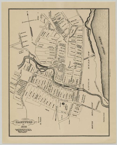
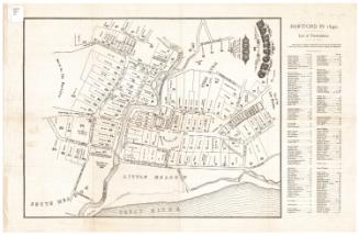
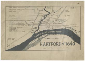
Hartford in 1640
After a work byAfter a work by
William S. Porter
American, about 1800 - 1866
PrinterPossibly printed by the
Dodd Lithographic Company
American, 1899 - 1909
Datepossibly 1899-1909
MediumLithography; black printer's ink on wove paper
DimensionsPrimary Dimensions (image height x width): 12 1/4 x 9 11/16in. (31.1 x 24.6cm)
Sheet (height x width): 13 5/8 x 11in. (34.6 x 27.9cm)
Sheet (height x width): 13 5/8 x 11in. (34.6 x 27.9cm)
ClassificationsGraphics
Credit LineGift of the Society of the Descendants of the Founders of Hartford
DescriptionMap of Hartford, Connecticut, as it appeared in 1640, with a cow pasture to the north, the Great (Connecticut) River to the east, the South Meadow to the south, and the West Field to the west. Roads are lined with land lots which are labeled with the owner's name. Small squares representing buildings are shown at the edges of the lots.
Object number1987.284.0
MarkingsRecto, bottom left and right corners, printed in black ink on stickers: "MAPS / Box / 269"Verso, center, stamped in blue ink: "CtHi"InscribedRecto, bottom left corner, printed in black ink: "HARTFORD / in / 1640 / Prepared from the Original Records / by Vote of the Town, and drawn by / William S. Porter / Surveyor & Antiquarian"
Right side, printed in black ink: "Dodd. Hartford Conn."
Verso, top left corner, handwritten in pencil: "MAPS / Box / 269"
Center, handwritten in pencil: "087385"NotesCartographic Note: No scale
Date Note: Dodd's Lithographic Company, who may have printed this map, were in business from 1899 to 1909. It seems likely that the map dates from this period.
Collections
- Maps and Charts: Finding Your Place in Connecticut History
On View
Not on view
Silvermine Production
1973

Sherman Wolcott Adams
1885