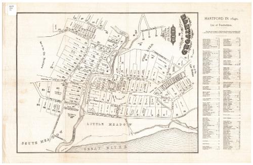
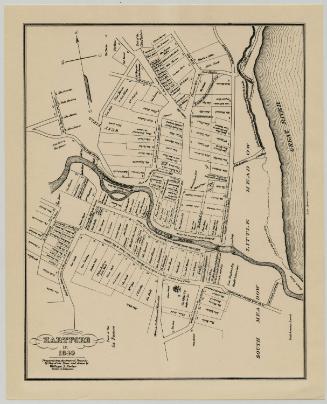
Hartford in 1640
SurveyorSurveyed by
William S. Porter
American, about 1800 - 1866
DraftsmanDrawn by
William S. Porter
American, about 1800 - 1866
PrinterPrinted by
Unknown
Dateafter 1851
MediumLithography; black printer's ink on wove paper
DimensionsPrimary Dimensions (image height x width): 16 1/8 x 12 1/2in. (41 x 31.8cm)
Sheet (height x width): 22 x 14 1/4in. (55.9 x 36.2cm)
Sheet (height x width): 22 x 14 1/4in. (55.9 x 36.2cm)
ClassificationsGraphics
Credit LineConnecticut Museum of Culture and History collection
DescriptionMap of Hartford as the city was laid out in 1640, and oriented east-west on the sheet. It extends from "Part of the Cow Pasture" to the north, the Connecticut River ("Great River" on the map) to the east, "Part of the Ox Pasture" to the south, and the West Field to the west. The Little River runs east-west to where it meets the Connecticut River. Land lots are numbered and contain a square that presumably represents the location of the building on it, and the name of the property owner and, in some cases, the name of the individual to whom it was sold. To the right of the map is an alphabetical list of freeholders and their corresponding lot numbers. The roads are not named, as such, but they are labeled with descriptions of where they come from or lead. Public spaces, such as the meeting house yard, "prison jail," and market place are included, as are roads.
Object number2012.312.210
MarkingsRecto, top right, printed in black ink on sticker: "MAPS / Box / 81"Verso, center, stamped in blue ink: "CtHi"InscribedRecto, top, printed in black ink: "HARTFORD / in / 1640"
Top, printed in black ink: "Prepared from the Original Records / By Vote of the Town / and Drawn by / William S. Porter. / Surveyor & Antiquarian. / in 1838."
Verso, top leftt corner, handwritten in pencil: "Map Box #81"
Bottom left corner, handwritten in pencil: "MAP Box 81"
Names of the property ownership indicated on the map include:
On the Highway on the Bank of the River:
William Goodwin elder, Samuel Stone (teacher), Thomas Hooker (pastor), Richard Webb (later this property is sold to John Haynes Esq.), Thomas Standley, Thomas Lord, Richard Lord, Thomas Lord Jr.
On the Road from Little River to North Meadow:
James Olmsted, William Pantry, Thomas Scott, Edward Stebbins, Timothy Stanley, John Store to John Marsh, William Butler, Matthew Allen to John Barnard to Thomas Woodford, William Westwood, Stephen Hart, Matthew Marvin, Nicholas Clark, Matthew Allen
On the Road fom the Palisado to Centinel Hill:
Richard Olmsted, John Skinner to Richard Olmsted, Sam Whitehead (later sold to Richard Lord), Edward Hopkins (later sold to Thomas Alcock), John Haynes (later sold to John Pratt), John Pratt, John Maynard, Richard Webb, Mrs. Dorothy Chester
On the Road from the Centinel Hill to the Neck:
William Kelsey, Stephen Hart, Matthew Marvin, Nicholas Clark (later sold to Thomas Alcott), William Heaten (Hayden?), John Brounson, Richard Clark
On the Road from the Centeniel Hill to the Cow pasture:
John Holaway, Thomas Spencer, William Spencer (later sold to Richard Church), Zachariah Field, Thomas Root, Benjamine Munn, Sam Hale, Benjamin Burr, John Warner, William Pratt, Nicholas Ginnings (later sold to Robert Wade), Daniel Gerrard, Nicholas Dishbro, Richard Seamer, Thomas Porter, Thomas Upson, Thomas Barnes, Thomas [illegible] (later sold to Nicholas Ginnings), John Purchas
On the Road from Centinel Hill to Brick Hill:
William Phillips, Thomas Munson (later sold to Matthew Kellogg)
On the Road from Seth Granis to Centinel Hill:
Thomas Hales, Ozias Goodwin, Thomas Birchwood, John Clark, William Parker, William Russell, William Wadsworth
On the Road from the Meeting House to the Mill
Seth Grant, John Biddell, Mary Betts, Nathaniel Richards, Timothy Stanley
On the Road from Mill to Country/Old Ox Pasture to Cow Pasture:
John Hall and William Spencer, John Skinner, John Morrice, Nathaniel Barding, John Ginnings
On the Road from the Mill to the South Meadow and Highway on the Bank of the River:
John Wilcock, Ralph Keeler, William Gobbins (later sold to John Friend John Hale but of Blumfield), William Blumfield, William Andrews, John Hopkins, Thomas Alcock, Arthur Smith, Jonas Ince to Captain John Cullik, Gregory Wilterton, Francis Andrews, John Baysey, Joseph Easton, Jeremy Adams, James Ensign, Marshall George Graves, Arthur Smith (later sold half to Barnard), John Barnard, Gregory Wilterton, Samuel Greenhills heir, Andrew Bacon, Nathan Ward, Andrew Warner, Samuel, Wakeman, William Hills
On the Road to Wethersfield to Ox Pasture:
John White (J White sold Gov. Hopkins the North End of his lot in exchange for a strip on the East of his South End), William Gibins (of great wealth and business), William Whiting, John Webster, Thomas Welles, Thomas Hosmer, John Judd, James Cole, Edward Hopkins Esq (bought 3 house lots)
On the Road from George Steele's to the South Meadow and Giles Smith to William Gibbins:
George Steele, George Stocking, Stephen Post, Phillip Davis (later sold to Nathaniel Ward), Thomas Bull, Richard Lyman, John Arnold, William Hide, Thomas Gridley, John Moody, John White, George Wyllys Esq (bougth several lots), J. Wakeley, G. Hubbard
On the road from George Steele to the Great Swamp:
John Mygatt, William Holton, Paul Peck, Henry Wakeley, Richard Watts, William Watts, William Westley, Edwawrd Leary, John Olmsted, John Pierce, Richard Risley, George Steele
On the Road to River and to J. Barnard's:
Thomas Bruce, John Series, Thomas Richards, Rob Bartlett, John Barnard, William HoltonNotesCartographic Note: No scale
Date Note: Although the map was surveyed and drawn in 1838, it apparently was not printed until 1851.
Collections
- Maps and Charts: Finding Your Place in Connecticut History
On View
Not on view

Silvermine Production
1973